Single-Edition Quadrangle Maps
Fact Sheet 094-98 (August 1998)
|| Introduction ||
Are Single-Edition Maps Different ||
|| Single-Edition Map Revision ||
Availability ||
 |
|
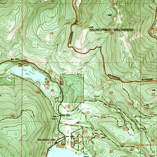
A part of the Metaline
Falls, Washington, single-edition quadrangle |
Introduction
In August 1993, the U.S. Geological Survey's (USGS) National
Mapping Discipline and the U.S. Department of Agriculture's
Forest Service signed an Interagency Agreement to begin a
single-edition joint mapping program. This agreement established
the coordination for producing and maintaining single-edition
primary series topographic maps for quadrangles containing
National Forest System lands. The joint mapping program saves
money by eliminating duplication of effort by the agencies and
results in a more frequent revision cycle for quadrangles
containing national forests. Maps are revised on the basis of
jointly developed standards and contain normal features mapped
by the USGS, as well as additional features required for
efficient management of National Forest System lands.
Single-edition maps look slightly different but meet the
content, accuracy, and quality criteria of other USGS products.
The Forest Service is responsible for the land management of
more than 191 million acres of land throughout the continental
United States, Alaska, and Puerto Rico, including 155 national
forests and 20 national grasslands. These areas make up the
National Forest System lands and comprise more than 10,600 of
the 56,000 primary series 7.5-minute quadrangle maps (15-minute
in Alaska) covering the United States. The Forest Service has
assumed responsibility for maintaining these maps, and the USGS
remains responsible for printing and distributing them.
Before the agreement, both agencies published similar maps of
the same areas. The maps were used for different purposes, but
had comparable types of features that were revised at different
times. Now, the two products have been combined into one so that
the revision cycle is stabilized and only one agency revises the
maps, thus increasing the number of current maps available for
National Forest System lands. This agreement has improved
service to the public by requiring that the agencies share the
same maps and that the maps meet a common standard, as well as
by significantly reducing duplication of effort.
|| Top || Main table
of contents ||
Are Single-Edition Maps Different?
'Yes' and 'No.' Single-edition maps are different in some
ways when compared with the standard quadrangle map, but they
are the same in most other ways because single-edition maps are
produced with the same set of standards. Nevertheless, the
differences are actually beneficial for map users because
single-edition maps provide more information than standard maps.
Standard maps also have been improved by the incorporation of
international symbols for recreational features, such as
campgrounds and picnic areas, and the enhancement of Federal
land boundaries.
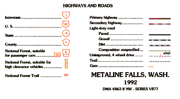 |
|
The Expanded "Highways
and Roads" legend for single-edition maps. |
Single-edition maps are different because they have about 25
additional features. Several features needed by the Forest
Service to manage our national forests efficiently have been
combined with features traditionally shown on USGS
general-purpose topographic maps. For example, the surface
construction of light-duty roads is further defined as paved,
gravel, dirt, or unspecified. Symbols for forest routes provide
information on whether or not a road is passable by
high-clearance or low-clearance vehicles. Single-edition maps
show additional forest administrative and land status
boundaries, as well as protracted and surveyed township and ange
information of the Public Land Survey System. Private property
inside the national forest boundary is portrayed with a
light-gray tint. The maps are still projected on the NAD27
datum. Lastly, these maps show Forest Service campground names,
indicate trailheads, and use a few cartographic enhancements of
other symbols and margin information to emphasize some of the
multiple public uses of the Forest System lands.
Single-edition maps are the same as traditional quadrangle
maps in that they retain the same 7.5-minute, 1:24,000-scale
format, contours, and other conventional features and symbols.
The standards for revising all quadrangle maps were developed
jointly by the USGS and the Forest Service. The quality in terms
of content, names, and labels is the same. The positional
accuracy of well-defined features shown on the existing map is
maintained during revision. Therefore, maps having the National
Map Accuracy statement should continue to meet accuracy
standards.
|| Top || Main table
of contents ||
Single-Edition Map Revision
In a perfect world, all features on all quadrangle maps would
be revised at the same time, giving a true and complete snapshot
of the ground on the date of map publication. Unfortunately for
map users, this is not economically possible; thus, for all
quadrangle maps we have defined two kinds of revision: basic and
complete. For basic revision, only certain features that can be
positively identified from imagery (for example, aerial
photographs, digital orthophotos, satellite images, and so on)
are revised. Map content is revised by adding new features,
modifying features that change, and deleting features that no
longer exist. Generally, there is no field checking and the
contours are left as they were originally drawn. The positional
accuracy of features on the previous edition of the map is
maintained.
For complete revision, all feature content is revised, there
is field verification, and the contours are updated. The
positional accuracy of each feature is improved as necessary.
Revision of single-edition maps, like that of most standard
USGS maps, usually follows basic revision guidelines, with some
notable exceptions. The Forest Service does some field checking,
especially for areas within the national forest boundaries. On
quadrangles having both Forest System lands and non-Forest
System lands, the revision is not exhaustive; that is, features
inside the national forest boundary are comprehensively revised,
but only certain features may be revised outside the boundary.
The kinds of features that may be revised outside of Forest
System lands are those that provide access to public land, those
that continue from one map to the next, or those features that
are large in area and highly visible. Examples include four-lane
highways, large reservoirs, high-voltage powerlines, public
access roads, and the Public Land Survey System.
|| Top || Main table
of contents ||
Availability
Standard USGS 7.5-minute maps (15-minute in Alaska) cover the
entire United States and its possessions. The USGS and the
Forest Service are in the process of converting the maps
covering National Forest System lands to single-edition
versions. Currently, not all national forests have
single-edition map coverage; however, complete coverage could be
realized near the year 2010.
For information on these and other products and services,
contact one of customer service representatives at
800-248-6277 or
Sales@GeoMart.com
|| Top || Main table
of contents ||
|


