The Universal Transverse Mercator (UTM)
Grid
Fact Sheet 077-01 (August 2001)
|| Map Projections ||
Grids ||
The Universal
Transverse Mercator Grid ||
||
Determining a UTM Grid Value for a Map Point ||
Information ||
The most convenient way to identify points on the curved
surface of the Earth is with a system of reference lines called
parallels of latitude and meridians of longitude. On some maps,
the meridians and parallels appear as straight lines. On most
modern maps, however, the meridians and parallels appear as
curved lines. These differences are due to the mathematical
treatment required to portray a curved surface on a flat surface
so that important properties of the map (such as distance and
areal accuracy) are shown with minimum distortion. The system
used to portray a part of the round Earth on a flat surface is
called a map projection.
|| Top || Main table
of contents ||
To simplify the use of maps and to avoid the inconvenience of
pinpointing locations on curved reference lines, cartographers
superimpose on the map a rectangular grid consisting of two sets
of straight, parallel lines, uniformly spaced, each set
perpendicular to the other. This grid is designed so that any
point on the map can be designated by its latitude and longitude
or by its grid coordinates, and a reference in one system can be
converted into a reference in another system. Such grids are
usually identified by the name of the particular projection for
which they are designed.
|| Top || Main table
of contents ||
 |
|
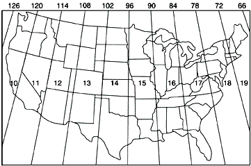
Figure 1. The
Universal Transverse Mercator grid that covers the
conterminous 48 United States comprises 10 zones—from
Zone 10 on the west coast through Zone 19 in New
England. |
The National Imagery and Mapping Agency (NIMA) (formerly the
Defense Mapping Agency) adopted a special grid for military use
throughout the world called the Universal Transverse Mercator (UTM)
grid. In this grid, the world is divided into 60 north-south
zones, each covering a strip 6° wide in longitude. These zones
are numbered consecutively beginning with Zone 1, between 180°
and 174° west longitude, and progressing eastward to Zone 60,
between 174° and 180° east longitude. Thus, the conterminous 48
States are covered by 10 zones, from Zone 10 on the west coast
through Zone 19 in New England (fig. 1). In each zone,
coordinates are measured north and east in meters. (One meter
equals 39.37 inches, or slightly more than 1 yard.) The northing
values are measured continuously from zero at the Equator, in a
northerly direction. To avoid negative numbers for locations
south of the Equator, NIMA's cartographers assigned the Equator
an arbitrary false northing value of 10,000,000 meters. A
central meridian through the middle of each 6° zone is assigned
an easting value of 500,000 meters. Grid values to the west of
this central meridian are less than 500,000; to the east, more
than 500,000.
Virtually all NIMA-produced topographic maps and many
aeronautical charts show the UTM grid lines.
|| Top || Main table
of contents ||
 |
|
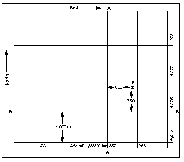
Figure 2. The grid
value of line A-A is 357,000 meters east. The grid value
of line B-B is 4,276,000 meters north. Point P is 800
meters east and 750 meters north of the grid lines;
therefore, the grid coordinates of point P are north
4,276,750 and east 357,800. |
The UTM grid is shown on all quadrangle maps prepared by the
U.S. Geological Survey (USGS). On 7.5-minute quadrangle maps
(1:24,000 and 1:25,000 scale) and 15-minute quadrangle maps
(1:50,000, 1:62,500, and standard-edition 1:63,360 scales), the
UTM grid lines are indicated at intervals of 1,000 meters,
either by blue ticks in the margins of the map or with full grid
lines. The 1,000-meter value of the ticks is shown for every
tick or grid line. In addition, the actual meter value is shown
for ticks nearest the southeast and northwest corners of the
map. Provisional maps at 1:63,360 scale show full UTM grids at
5,000-meter intervals.
To use the UTM grid, you can place a transparent grid overlay
on the map to subdivide the grid, or you can draw lines on the
map connecting corresponding ticks on opposite edges. The
distances can be measured in meters at the map scale between any
map point and the nearest grid lines to the south and west. The
northing of the point is the value of the nearest grid line
south of it plus its distance north of that line; its easting is
the value of the nearest grid line west of it plus its distance
east of that line (see fig. 2).
On maps at 1:100,000 and 1:250,000 scale, a full UTM grid is
shown at intervals of 10,000 meters and is numbered and used in
the same way.
|| Top || Main table
of contents ||
For information on these and other products and services,
contact one of customer service representatives at
800-248-6277 or
Sales@GeoMart.com
|| Top || Main table
of contents ||
|


