|
Understanding Color Infrared (CIR)
Aerial
Photography
Images obtained by satellites and high-altitude aircraft give
engineers and scientists a tool to study landforms, vegetation health
patterns, environmental pollution, and other effects of human
activities on the planet's surface.
Satellites and high-altitude aircraft equipped to record scenes of
the Earth use both visible and invisible parts of the electromagnetic
spectrum. Near-infrared light is invisible to the human eye, but
adding it to these images allows scientists to "see" the surface of
the Earth in other than natural colors. The result is "color-infrared"
photography.
The electromagnetic spectrum is the scientific term for the
collective types of light and energy emitted from the Sun. The part of
the spectrum visible to the human eye is the normal rainbow of colors
we see every day. Passing sunlight shining through a prism separates
white light into individual colors, just as sunlight through raindrops
creates a rainbow. More technically, a prism divides light into its
component wavelengths. Ripples on a lake can be close together or far
apart and are analogous to light wavelenths and how closely they are
spaced.
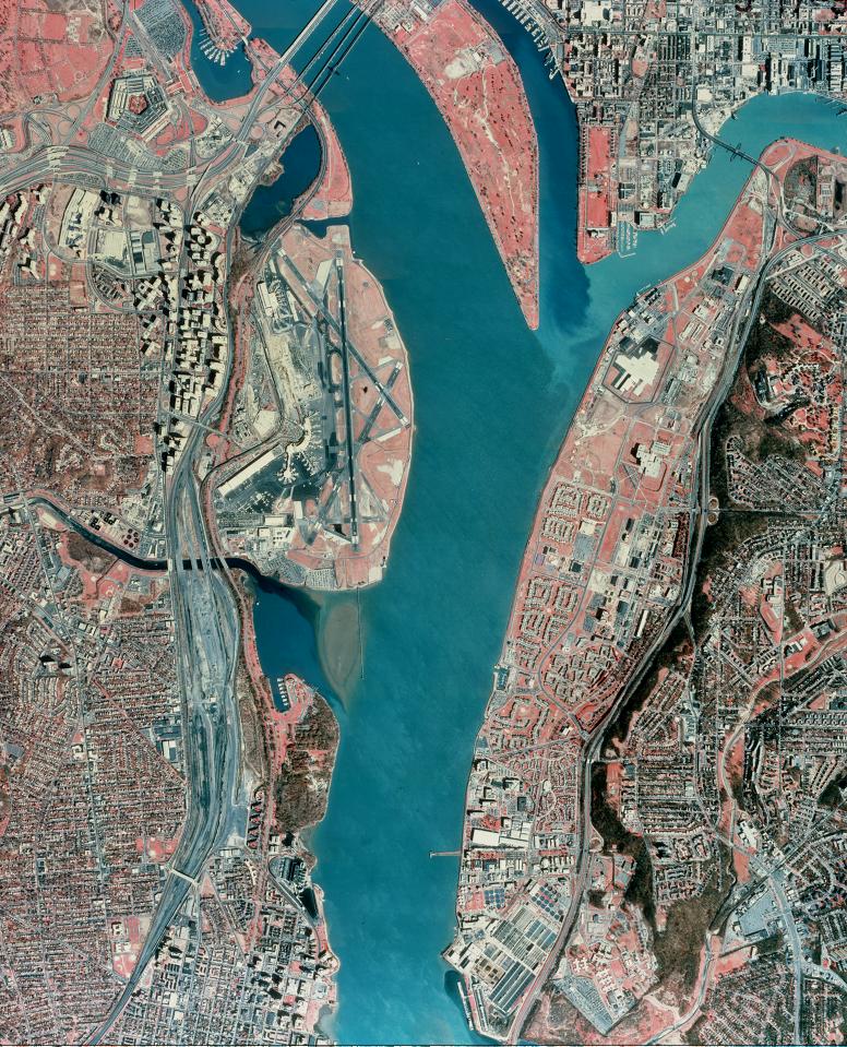
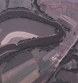
 |
| NASA color-infrared photograph—New
Orleans, La. |
| |
Other parts of the spectrum—such as the invisible near-infrared
wavelengths—can be recorded by either electronic sensors or special
photographic films sensitive to these wavelengths. These sensors and
films record the energy reflected by the ground and the Sun's spectral
energy. The color-infrared film images referred to in this fact sheet
should not be confused with electronic thermography (thermal
recordings), a process in which long-wave or "far-infrared" radiation
is electronically detected and subsequently displayed at visible
wavelengths. Near-infrared and visible wavelengths that are
simultaneously recorded combine to provide a unique view of the
Earth's vegetation and other features of the planet's surface.
This unique aerial view, created by a combination of wavelengths,
gives scientists a means to better understand what is happening on the
Earth's surface. For example, leaves of healthy, growing vegetation
reflect a high level of near-infrared wavelengths and appear red on
color-infrared film. Unhealthy or dormant vegetation may appear light
red or a light shade of blue-green (cyan), depending on the plant's
degree of good health. These color distinctions make color-infrared
photographs useful in assessing the health of plants. Water, on the
other hand, absorbs near-infrared wavelengths and appears black in the
image. Water with varying amounts of suspended particles appears as
shades of blue. Also, near-infrared wavelengths penetrate atmospheric
haze and result in clear, crisp images. This is an important
consideration when collecting satellite images and high-altitude
aerial photographs.
Satellite electronic sensors and aerial color-infrared films both
record visible and near-infrared wavelengths, but each of these
systems requires different laboratory processes. Here is how they
work.
 |
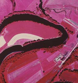 |
| Color photograph—near Burlington, Vt. |
Color-infrared photograph—near same
area |
| Top |
Color-Infrared Photographs
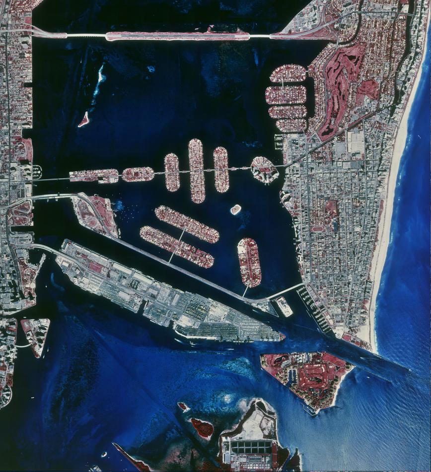
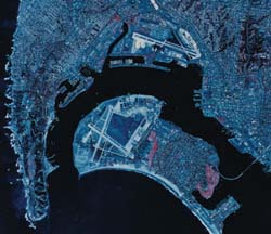 |
NASA color-infrared color
photograph—San
Diego, Calif. |
| |
Both standard-color and color-infrared films are manufactured to
have three distinct layers, or emulsions. Each layer is sensitive to
different wavelengths or energy. Standard-color film emulsions
normally record the visible wavelengths as red, green, and blue. After
the picture has been taken, chemical processing of the film generates
cyan, magenta, and yellow dyes proportional to the amount of exposure
given each layer. Color pictures result when the human eye views the
varying combinations of the three dye layers. Color-infrared film has
a yellow filter over the three emulsion layers to block ultraviolet
(UV) and blue wavelengths. Processing color-infrared film after
exposure produces yellow, magenta, and cyan dyes. The near-infrared
wavelengths and the lack of UV and blue wavelengths result in a clear,
crisp color-infrared image. Green, healthy vegetation has a high
reflection level of near-infrared wavelengths and appears red on the
processed film; red objects with very low near-infrared reflection
appear green; green objects with very low near-infrared reflection
appear blue; and blue objects with very low near-infrared reflection
appear black.
| Top |
Color-Infrared Composite Images
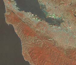 |
Landsat color-infrared composite—San
Francisco, Calif. |
| |
Another type of color-infrared image is the color-infrared
composite of multispectral data collected by electronic sensors on
satellites such as Landsat. These sensors record the light levels of
Earth's reflected energy (from blue/green wavelengths through infrared
wavelengths) and transmit these data in digital format to the ground
in sets of four or seven wavelength-dependent bands for each typical
Landsat scene. On the ground, the digital image data may be converted
to hardcopy images similar in appearance to conventional
color-infrared photographs. Computerized image-recording devices
process the bands of green, red, and near-infrared digital data,
exposing conventional color film or paper with blue, green, and red
light, respectively. In the resulting image, growing healthy
vegetation appears red, clear water appears black, sediment-laden
water appears light blue, and urban areas appear blue-gray.
| Top | |