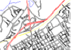
The vector 7.5 minute quad maps are CAD/GIS drawings where each
road, stream, and contour line are individual entities. This is
completely different from Raster quad maps which are simply
paper maps that have been run through a scanner and
geo-referenced.
The entities on our vector maps are on many different layers,
according to their type. For example, major roads are on a
different layer than minor roads or streams. Additionally,
contour lines are 3D polylines. This makes for a very easily
manipulated CAD or GIS drawing.
The difference between Vector maps and Raster maps is
analogous to the difference between a word processing document
and a scanned document. The word processing document is a whole
lot easier to change, move words around, add new paragraphs, or
run a spelling checker than a scanned document. Likewise, it is
much easier to modify, move, add new entities, or analyze a
vector CAD drawing than the corresponding scanned map.
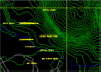
This vector data also provides access to the USGS Digital
Elevation Models (DEM) that are used to generate the 3D contour
lines. Several output formats, including DEM and XYZ ASCII files
allow your 3D Surface Analysis Program to use the DEM data.
Vector Graphics Features:
|
 |
Vector
CAD/GIS line work, not scanned quad sheets.
|
|
|
3D contours
from USGS DEMs
at any contour interval. |
|
|
Different
layers for map features. |
|
|
Seamless
tiling of multiple quads. |
|
|
Geo-referenced coordinate systems, including state plane,
lat-long, UTM, NAD83 and NAD27.
|
|
|
GPS
compatible, labeled streets and landmarks.
|
|
|
Multiple CAD
and GIS output
file options, DWG, DXF, DGN, SHP, and MIF.
|
|
|
XYZ and DEM
elevation files for terrain and hydrology analysis. |
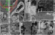
Each State and County data set include all data and user
interface to extract the data exactly as you like. Options
include layers needed, mosaicing adjoining maps, contour
intervals, projection system, file format, double lined roads,
and 3D elevation data.
See Screen Capture
|