Featured Products

See some of our other fine products

Click on image for more information

Search our Site

Build you own USGS topographic map

The Perfect Gift


Gift Certificates


Tell a friend

about GeoMart:

Acceptance Mark

Pre-Approved Purchase Orders

GeoMart

516 Villanova Court

Ft Collins, CO 80525

800-248-6277

800-321-6277 Fax

free map maps mapping drg doq doqq digital raster graphic digital raster graphic ortho orthos orthorectified rectified quarter quad quarter quads
quad, quads USGS United States Geological Survey NED DEM national elevation dataset elevation models digital elevation model vector topo
topos usgs topos usgs quads 1:24000 usgs topographic maps aerial photography digital aerial photography topos on cd dvd aerial photography
on cd dvd download datum projection reprojection topographic autocad maps autocad maps digital maps digital elevation model DEM hypsography
tiger public land grid cad maps contour lines 24k DRG raster DRGs scanned digital topo on cd seamless elevation countours plss township range
section dlg dwg digital line graph DOQ DOQQ DRG NED Vector dxf dgn mid mif autocad microstation mapinfo topo maps cdmaps street maps
topographic gps usgs topomaps digital maps online maps topodepot base utilities mapping aerial photography mining contours gis arcinfo shp
shape files civil engineering softdesk gis maps vector 7.5 minute quad quad maps environmental engineer contour maps surveying USGS aerial
aerial photograph atlas digital extreme storms doq doqq drg drgs floods geographic geographic names geological geology geospatial data gis
geography information GLIS, Global Land Information System government hurricanes map mapping free map free topo free topographic maps
mineral minerals mineral resources noaa charts nautical charts raster spatial data National Atlas news news releases photos publications quad
quads real-time water data research science scientists storms students teachers topo topographic topographic maps usgs us geological survey
volcanoes water water use geochron map maps geochron world watch screen saver software geochron global time indicator AM analemma
autumnal equinox boardroom cancer capricorn chronometers clock contemporary conversation piece date day daylight saving time daylight earth
equation of time equator equinox executive gifts executive finish finishes gray lines greenwich apparent time greenwich mean time Greenwich
Kilburg original kilburg latitude legal time local time longest day longitude mercator meridian model models noon original PM screen saver
shortest day solstice summer solstice standard sun sunrise sunset time zones time tropic of capricorn ultimate clock ultimate unique clocks vernal
equinox winter solstice world affairs world watch screen saver zenith national geographic maptech delorme magnabrite magnabright county map
books universal space shot space shots satellite images custom mapping custom scanning scan noaa nima nos brunton scalex replogle globes
hubbard scientific raised relief maps 3d maps arcview
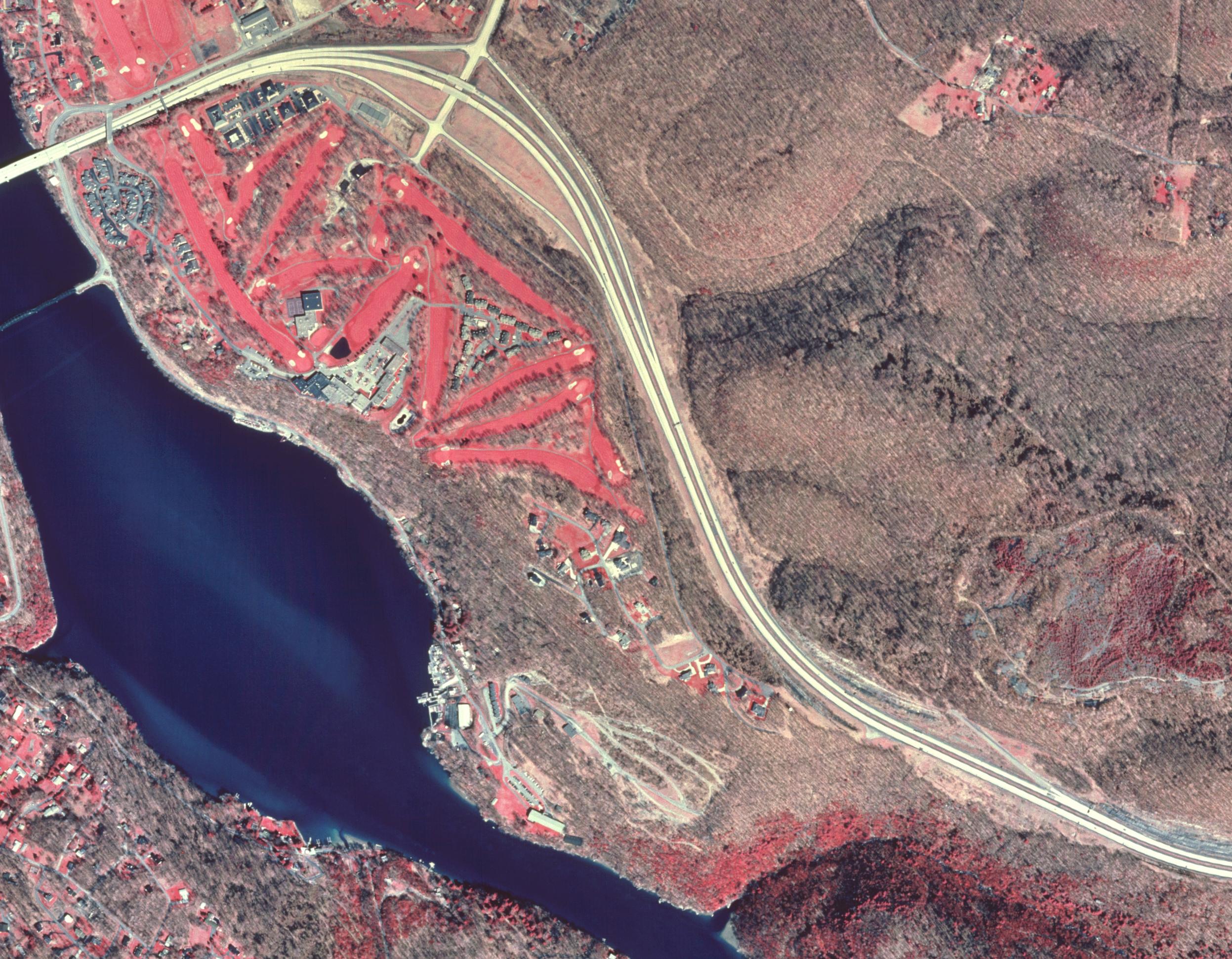
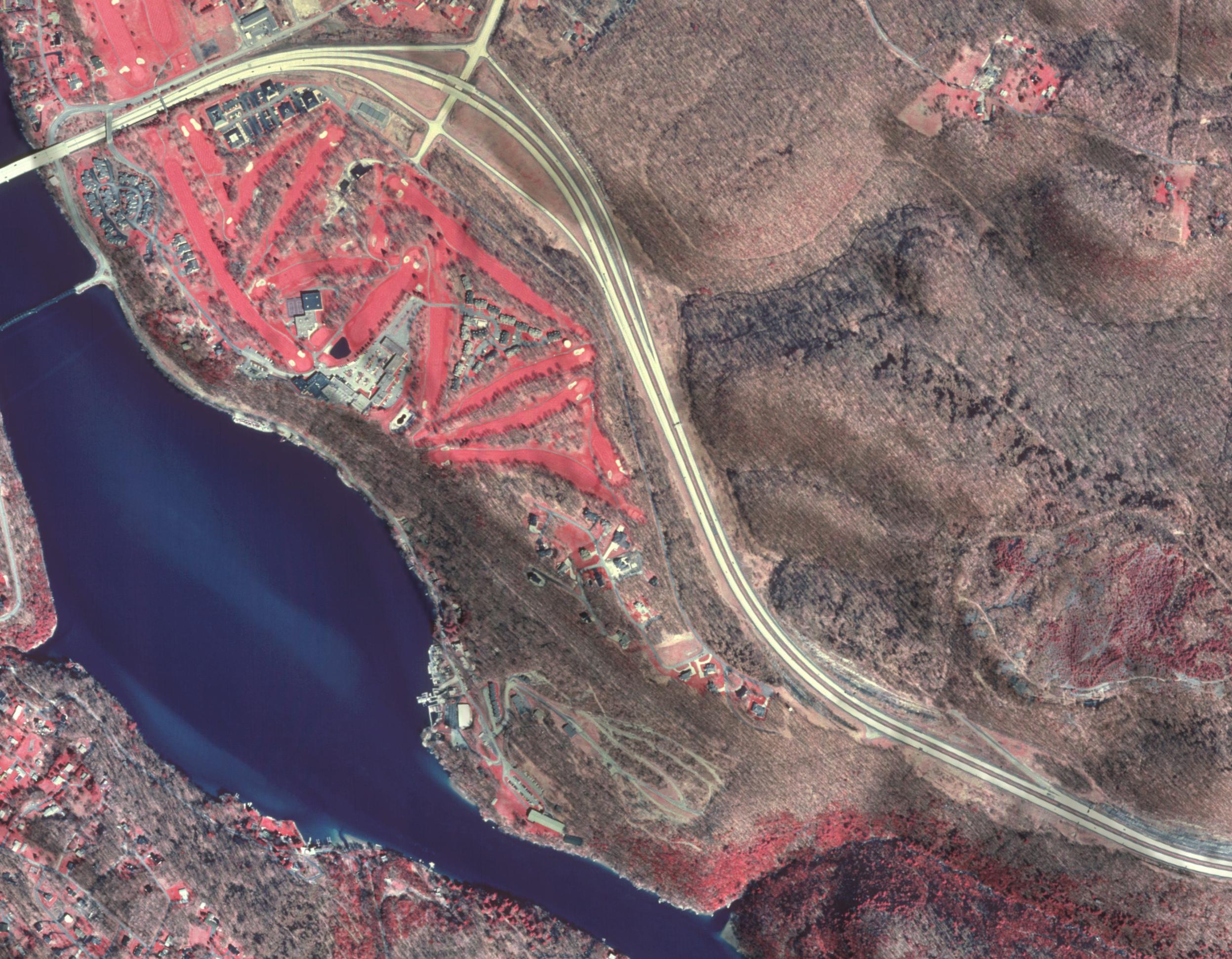
Digital Orthophotos - DOQQ / DOQ


Color Infrared (CIR) Digital Orthophoto (DOQ) of Lake Lynn WV Portion of Digital Orthophoto (DOQ) of Lake Lynn WV with hillside shading Portion of Digital Orthophoto (DOQ) of Lake Lynn WV quad with Digital Raster Graphic (DRG) overlay Portion Digital Orthophoto (DOQ) of Lake Lynn WV with National Wetland Inventory overlay Portion of Digital Orthophoto (DOQ)  of Lake Lynn WV with Digital Raster Graphic (DRG) and Vector Data overlays


Go to Digital Orthophoto (DOQ) Home

Download Samples of Digital Orthophoto (DOQ) Data

Pricing and ordering information for Digital Orthophotos (DOQ)

View Status of Digital Orthophoto (DOQ) Availablity


A digital orthophoto quadrangle (DOQ) is a computer-generated image of an aerial photograph in which image displacement caused by terrain relief and camera tilts has been removed. It combines the image characteristics of a photograph with the geometric qualities of a map.

Characteristics of a USGS Digital Orthophoto Quadrangle

DOQs produced by the U.S. Geological Survey (USGS) are either gray-scale, natural color, or color-infrared (CIR) images with 1-meter ground resolution. They cover an area measuring 3.75-minutes longitude by 3.75-minutes latitude or 7.5-minutes longitude by 7.5-minutes latitude. Each DOQ has between 50 and 300 meters of overedge image beyond the latitude and longitude corner crosses embedded in the image. This overedge facilitates tonal matching and mosaicking adjacent images.

The standard DOQ is formatted with an ASCII keyword header followed by a series of 8-bit binary image lines. Color DOQs are 24-bit band-interleaved-by-pixel (BIP) images. The header contains a wide range of data for identifying, displaying, and georeferencing the image.

All DOQs are referenced to the North American Datum of 1983 (NAD 83) and cast on the Universal Transverse Mercator (UTM) projection. Primary (NAD 83) and secondary (NAD 27) datum coordinates for the upper left pixel are included in the header so that users can spatially reference other digital data to the DOQ.

The file size of a 3.75-minute gray-scale DOQ is 40-45 megabytes, and a 3.75-minute color or 7.5-minute gray-scale DOQ can be three times this size.

| Back to the top |

Producing a Digital Orthophoto Quadrangle

To produce a DOQ requires (1) a minimum of three ground positions that can be identified on the photograph to be rectified, (2) camera calibration parameters, such as the calibrated focal length and the coordinates of the camera fiducials, (3) a digital elevation model (DEM), and (4) a digital image produced by scanning an aerial photograph with a precise, high-resolution scanner.

The digital image is rectified to generate an orthophoto by processing requirements 1 through 3 above for each image picture element (pixel), using rigorous photogrammetric equations on a computer. The finished product is a spatially accurate image with planimetric features represented in their true geographic positions.

| Back to the top |

Accuracy Requirements

The accuracy and quality of USGS DOQs must meet National Map Accuracy Standards at 1:12,000 scale for 3.75-minute quarter quadrangles and at 1:24,000 scale for 7.5-minute quadrangles. Accuracy and quality depend on the following:

  • photographs that meet National Aerial Photography Program standards, which are quarter-quadrangle centered. The photographs are exposed at a flying height of 20,000 feet above mean terrain;
  • a DEM with the same area coverage as the DOQ and that is equal to or better than a level 1 USGS DEM having a root-mean-square error in elevation no greater than 7 meters;
  • a highly accurate image-scanning process that uses a scanning aperture between 7.5 and 32 micrometers (µm). A 1:40,000-scale image scanned with a 25µm aperture produces a ground sample distance of approximately 1 meter; and
  • identifiable ground control positions with coordinates acquired from ground surveys or aerotriangulation.

| Back to the top |

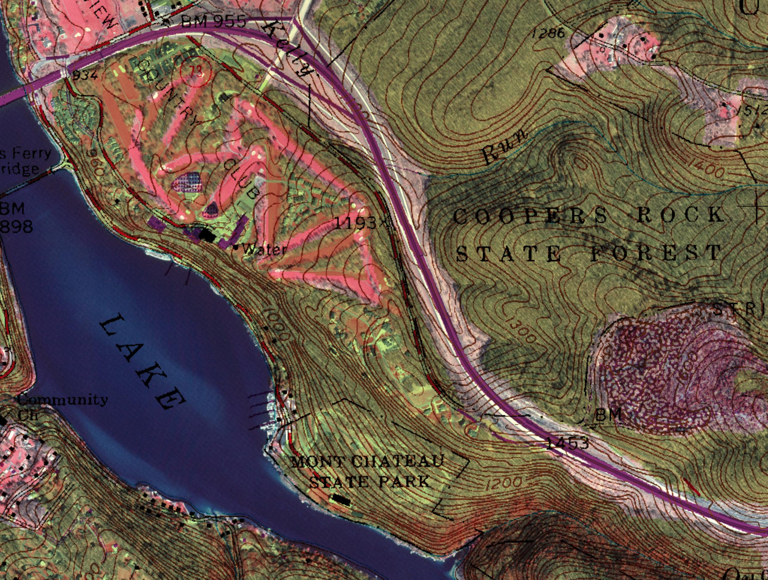
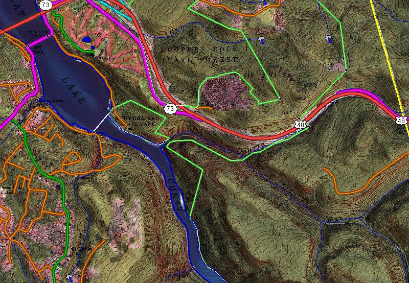
Uses for Digital Orthophoto Quadrangles

A DOQ can be incorporated into any geographic information system (GIS) or graphics software that can manipulate raster images. It can function as a cartographic base for displaying, generating, and modifying associated digital planimetric data. Other applications include vegetation and timber management, routing and habitat analysis, environmental impact assessments, emergency evacuation planning, flood analysis, soil erosion assessment, facility management, and ground-water and watershed analysis. The accuracy and extraordinary detail provided by the DOQ allow users to evaluate their data for accuracy and completeness, make real-time modifications to their data, and even generate new files.

| Back to the top |

Distribution Media

DOQs are distributed in either native (standard) or GeoTIFF format on a variety of media, including 8-mm tape, CD-R, DVD, and FTP as uncompressed files. DOQs covering selected counties are also available packaged as individual, JPEG-compressed files on CD-ROM. Note that the county DOQ products contain DOQs built to the pre-1997 (old) standard and do not contain the keyword header.

Obtaining Digital Orthophoto Quadrangles

DOQ files can be ordered by contacting us at 800-248-6277.  DOQ coverage is not available for all areas in the United States. View Status graphics.