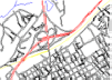
Featured Products

See some of our other fine products

Click on image for more information

Search our Site

Build you own USGS topographic map

The Perfect Gift


Gift Certificates


Tell a friend

about GeoMart:

Acceptance Mark

Pre-Approved Purchase Orders

GeoMart

516 Villanova Court

Ft Collins, CO 80525

800-248-6277

800-321-6277 Fax

Vector Topographic Data


Wilmington Vector Street Data 3D Contours 2D Contours of Old Faithful 3D View of Toas, NM with DOQQ overlay 2D mapping with DOQQ overlay

 
Vector Home Download Samples of Vector data Purchase Vector Data by the State Purchase Vector Data by the County


Taos, New Mexico

Toas is also a good example of a rural, mountainous area. Contours were generated at 40 feet because of the large amount of relief in the area. There is no 24K DLG data for the area, so the roads, streams, etc.,  were generated from the 100K DLG data. We then ran it again using just the TIGER data for roads, streams, etc., and picked up a few more streets in downtown Taos. This is fairly common in rural areas, as TIGER is essentially 100K DLG with some updates in rural areas.

DOWNLOAD

Choose a format:

AutoCAD DWG format  (R14)3.8MB  
AutoCAD DWG format (R11-12)2.6MB
AutoCAD DXF format (R14)2.9MB

Microstation 2D1.0MB
Microstation 3D1.0MB

ArcView SHP 2D2.2MB

MapInfo MIF 2D2.3MB

USGS DEM Surface File0.15MB

XYZ Ascii Surface File2.6MB

Note: In AutoCAD and Microstation, you will need to zoom to extents to see the drawing.