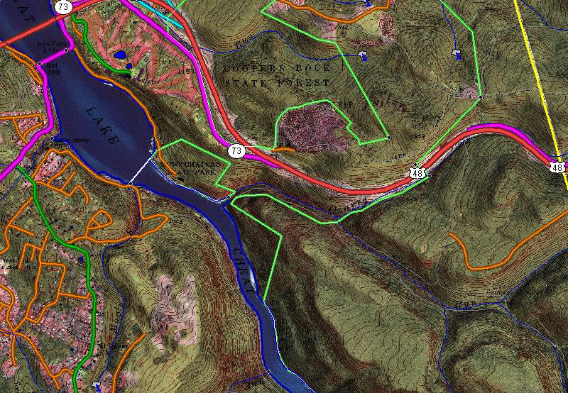
Featured Products

See some of our other fine products

Click on image for more information

Search our Site

Build you own USGS topographic map

The Perfect Gift


Gift Certificates


Tell a friend

about GeoMart:

Acceptance Mark

Pre-Approved Purchase Orders

GeoMart

516 Villanova Court

Ft Collins, CO 80525

800-248-6277

800-321-6277 Fax

free map maps mapping drg doq doqq digital raster graphic digital raster graphic ortho orthos orthorectified rectified quarter quad quarter quads quad, quads USGS United States Geological Survey NED DEM national elevation dataset elevation models digital elevation model vector topo topos usgs topos usgs quads 1:24000 usgs topographic maps aerial photography digital aerial photography topos on cd dvd aerial photography on cd dvd download datum projection reprojection topographic autocad maps autocad maps digital maps digital elevation model DEM hypsography tiger public land grid cad maps contour lines 24k DRG raster DRGs scanned digital topo on cd seamless elevation countours plss township range section dlg dwg digital line graph DOQ DOQQ DRG NED Vector dxf dgn mid mif autocad microstation mapinfo topo maps cdmaps street maps arcview topographic gps usgs topomaps digital maps online maps topodepot base utilities mapping aerial photography mining contours gis arcinfo shp shape files civil engineering softdesk gis maps vector 7.5 minute quad quad maps environmental engineer contour maps surveying USGS aerial aerial photograph atlas digital extreme storms doq doqq drg drgs floods geographic geographic names geological geology geospatial data gis geography information GLIS, Global Land Information System government hurricanes map mapping free map free topo free topographic maps mineral minerals mineral resources noaa charts nautical charts raster spatial data National Atlas news news releases photos publications quad quads real-time water data research science scientists storms students teachers topo topographic topographic maps usgs us geological survey volcanoes water water use geochron map maps geochron world watch screen saver software geochron global time indicator AM analemma autumnal equinox boardroom cancer capricorn chronometers clock contemporary conversation piece date day daylight saving time daylight earth equation of time equator equinox executive gifts executive finish finishes gray lines greenwich apparent time greenwich mean time Greenwich Kilburg original kilburg latitude legal time local time longest day longitude mercator meridian model models noon original PM screen saver shortest day solstice summer solstice standard sun sunrise sunset time zones time tropic of capricorn ultimate clock ultimate unique clocks vernal equinox winter solstice world affairs world watch screen saver zenith national geographic maptech delorme magnabrite magnabright county map books universal space shot space shots satellite images custom mapping custom scanning scan noaa nima nos brunton scalex replogle globes hubbard scientific raised relief maps 3d maps

Topographic Maps


Over 30 Years in Business

For over 30 years GeoMart has provided topographic maps to customers all over the world.  Now - fulfill all your topographic map needs with one call. Don't waste time searching for maps you need, or risk your project with unreliable delivery.

Call GeoMart at 800-248-MAPS or email us at customer@GeoMart.com. We will supply you with any map you need, when you need it, delivered anywhere in the world!

Ordering Information

To order  topo maps you can place your order by phone, by email or by fax.  We currently do not have online ordering of USGS topos.  We are currently working on an easy to use method of online ordering.

Delivery

If ordered before 1:00 pm eastern time, we will ship your USGS topographic maps the same day.  International topos usually ship within 3-5 days.  We offer Next Day, Second Day and Ground delivery options.


Now - fulfill all your topographic map needs with one call. Don't waste time searching for maps you need, or risk your project with unreliable delivery. Call GeoMart at 800-248-MAPS or Email to: customer@GeoMart.com. We will supply you with virtually any map you need, when you need it, delivered anywhere in the world!