|
Topographic Maps - International
Topographic Maps
International Topographic Maps
For topographic coverage outside of North America, GeoMart
offers to you the Tactical Pilotage Charts (TPC) and
the Operational Navigation Charts (ONC). The maps are produced
by the US government and are used by the military all over the
world. See more about these charts below.
Please note:
The charts available below are Print on Demand (POD) copies made
from scans of originals. The US government has discontinued
the distribution of the originals and are no longer available.
The charts are
shipped rolled, not folded.
|
|
|
Tactical Pilotage Chart (TPC)
The TPC is the standard worldwide medium- scale
aeronautical chart series (1: 500,000). TPCs provide essential cartographic
data appropriate to scale, and are overprinted with stable aeronautical
information such as contour lines, obstructions, special use air-space,
navigational aids, and related data. Cartographic data with aeronautical
overprint depicting obstructions, special use airspace, navigational aids
and related data. Because of scale, some features, including obstructions,
are generalized in developed regions. A Military Grid is overprinted for
interoperability. Designed for very low- altitude through medium- altitude
high- speed visual and radar navigation. TPCs are also used for mission
planning/ analysis and intelligence briefings, and are source for
navigational filmstrips, special purpose, and cockpit/ visual display
products.
Usually Ships in 2 Days
|
|
|
|
|
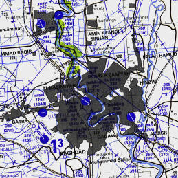
Operational Navigation Chart (ONC)
The ONC is the standard worldwide small- scale (1:
1,000,000) aeronautical chart series, and contains cartographic data with an
aeronautical overprint depicting obstructions, aerodromes, special use airspace,
navigational aides, Maximum Elevation Figures (MEFs), and related data. Because
of scale, some features, including obstructions, are generalized in developed
regions. A Military Grid is overprinted for interoperability, especially in
regions of no TPC coverage. Designed for medium altitude high- speed visual and
radar navigation. Also used for mission planning/ analysis and intelligence
briefings, and as source for navigational filmstrips, special purpose, and
cockpit/ visual display products.
|
|
|
|
Now - fulfill all your topographic map needs with one call. Don't
waste time searching for maps you need, or risk your project with
unreliable delivery. Call GeoMart
at 800-248-MAPS or
Email to:
customer@GeoMart.com. We will supply you with virtually
any map you need, when you need it, delivered anywhere in the world!
|