|
Wall Maps
- State, County & Cities - Alaska
GeoMart
is rapidly expanding its on-line selection of wall maps. If you
don't find what you are looking for here, please give us a call at
800-248-6277. One of our customer service representative will be
happy to assist you in finding the right map for you.
Most Maps Usually Ship within 48 hours.
Laminated maps with the option of hanging
rails usually ship in 5 days
|
 |
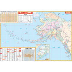
Alaska State
2004 1st edition
The
Alaska Wall Map by Universal Map includes the entire Aleutian
Islands, measures 64 by 45 inches, provides up-to-date
cartography, is printed in color, laminated, and indexed for
cities and counties on the face of the map.
|
|
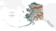 |
Raven Alaska Map
From glaciated mountain ranges to the tip of the
Aleutian Islands, the 49th state is one of most topographically
intriguing areas in the country. Elevations are represented by
color, and this, in combination with our relief shading
technique, gives the map a 3-dimensional look.
Raven Alaska Map Dimensions: 35" x
64" (approx.)
Raven Alaska Map Scale: 1:2.5 million or 1" equals about 40
miles |
|
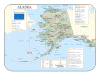 |
Alaska Shaded
Relief
The Alaska Shaded Relief Wall Map
measures 48" W x 36" H and is a full-color, topographical wall
map. The map's lamination makes the map able to be marked on and
wiped off easily. Lists state motto, bird, flower, and tree,
plus total area, population and origin of name. Includes
historical, anecdotal, and geographical. There is also an
elevation scale measured in meters and feet and a distance scale
measured in miles and kilometers. Shows state capital, and
international/state boundaries.
|
|
Click Price to Add to Cart |
| Laminated |
|
$31.95 |
|
|