|
Wall Maps
- State, County & Cities - Alabama
GeoMart
is rapidly expanding its on-line selection of wall maps. If you
don't find what you are looking for here, please give us a call at
800-248-6277. One of our customer service representative will be
happy to assist you in finding the right map for you.
Most Maps Usually Ship within 48 hours.
Laminated maps with the option of hanging
rails usually ship in 5 days
 |
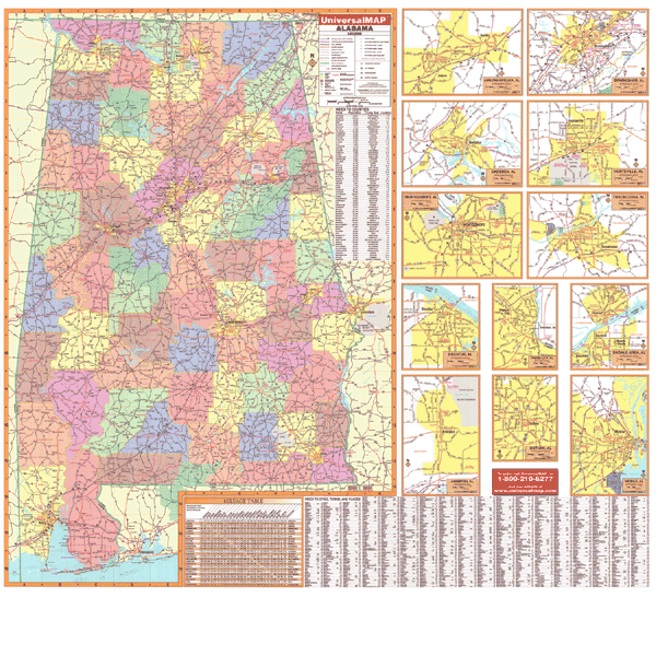
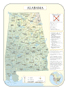
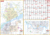
Alabama State
2005 3rd edition
The Alabama Wall Map measures 58" x
54" and features color-coded counties. Included inset maps
illustrate Anniston, Huntsville, Auburn/Opelika, Mobile,
Birmingham, Montgomery, Decatur, Phenix City, Dothan, Shoals
Area, Gadsen, and Tuscaloosa. Special features and data
contained on this map are as follows: all state and federal
highways, major waterways, towns, military installations, exit
numbers, an index to counties and county seats, major airports,
the state university, various points of interest, time zone
boundaries, cities, state parks, wildlife areas, a mileage
table, and a city-town-place index.
|
|
|
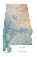 |
Raven Alabama Map
The map of Alabama extends from Huntsville and
the Sand Mountains in the north, through the low hills and sandy
valleys, and down to Mobile and the Gulf Coast. Elevations are
represented by color, and this, in combination with our relief
shading technique, gives the map a 3-dimensional look.
Raven Alabama Map Dimensions: 32" x 49"
Raven Alabama Map Scale: 1:500,000 or 1" equals about 8 miles |
|
 |
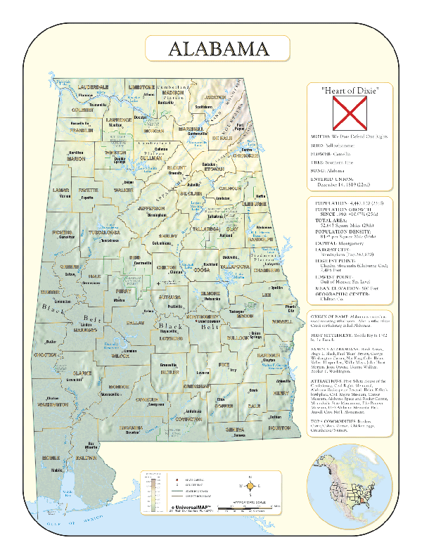
Alabama Shaded
Relief
The Alabama Shaded Relief Wall Map
measures 36" x 48" and is a full-color, topographical wall map.
The map's lamination makes the map able to be marked on and
wiped off easily. Statistical information on this map includes
historical, anecdotal, and geographical. There is also an inset
map of North America locating Alabama. Other data found with the
map are an elevation table, state capital, major cities,
counties, state and county boundaries, plus a scale showing
distances in miles and kilometers.
|
|
Click Price to Add to Cart |
| Laminated |
$31.95 |
|
 |
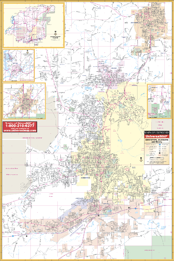
Anniston, AL
2000 1st Edition
The Anniston, AL Wall Map includes
the cities of Anniston, Hobson City, Jacksonville, Oxford, and
Weaver in complete street detail with the cities and boundaries
as follows: North to include Jacksonville: South to include
Oxford and one mile south of Anniston Metro Airport; East to
include De Armanville; and West to include the Anniston Army
Depot. The map's insets include Calhoun County, Ohatchee,
Piedmont, and White Plains. The special features and data
contained on this map are as follows: all streets and highways,
government buildings, shopping centers, airports, golf courses
and country clubs, water features, post offices, hospitals,
cemeteries, points of interest, range-section-township lines,
educational facilities, fire and police stations, city limits,
and annexations. This map measures 36" W x 51"H and is protected
by a laminate surface making the map durable and able to be
marked with water based pens.
|
|
 |
Auburn/Oplika, AL
2008
3rd Edition
The latest edition of the
Auburn/Opelika, AL Wall Map includes complete coverage of Lee
County. This wall map features all of Auburn/Opelika in complete
street detail with the boundaries as follows: North to the
Chambers County line; South to the Russell County line; East to
the Georgia state line; and West to the Tallapoosa County line.
There are insets of Auburn, Opelika, and Phenix City. Details
covered on this map are as follows: all streets and highways,
government buildings, airports, golf courses and country clubs,
points of interest, city limits and annexations, post offices,
shopping centers, cemeteries, water features, educational
facilities, fire and police stations, hospitals, recreational
parks, and railroads. This wall map measures 75" W x 52" H and
is protected by a laminated surface which is both markable and
washable.
|
|
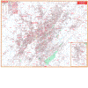 |
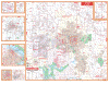
Birmingham, AL
2007
4th Edition
The Birmingham, AL Wall Map measures
66" x 54" and provides up-to-date cartography with new streets
and changes. This map is printed in color with a markable and
washable laminated surface. Streets are indexed in a separate
book. This map's area of coverage ranges North to include the
city of Gardendale; South to include the cities of Helena and
Alabaster; East to include the cities of Leeds and Moody, and
West approximately two miles West of Sylvan Springs and Virginia
to Port Birmingham. Details found on this map include all
streets, post offices, hospitals, railroads, mileage circles,
airports, cemeteries, shopping centers, water features,
recreational parks, government buildings, fire and police
stations, educational facilities, golf courses and country
clubs, zip codes, and zip code boundaries.
|
|
 |
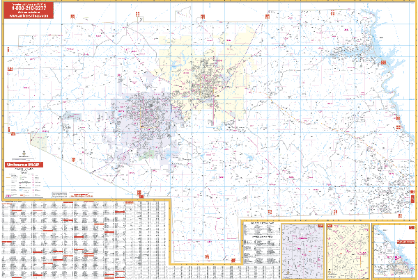
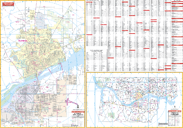
Florence/Muscle
Shoals, AL
2007 2nd Edition
The Florence and Muscle Shoals Area,
AL Wall Map measures 69” x 50” and provides up-to-date
cartography. The area of coverage includes the Florence and
Muscle Shoals area with the following boundaries: North: 1 mile
north of the Florence City limits; South: to Tuscumbia; East: to
the Northwest Alabama Regional Airport; West: to Sheffield.
Printed in color with a markable/washable-laminated surface.
Hanging rails are mounted on top and bottom for ease in hanging.
|
|
 |
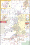
Huntsville, AL
2008
5th Edition
This Huntsville, Alabama Wall Map
provides up-to-date cartography plotted in completed street
detail with over 450 new streets and changes. Printed in color
and produced in durable lamination makes the surface both
markable and washable. Street indexing appears in a separate
book. Measures 5' 9" W x 4' 6" H. The area of coverage includes:
North to Hazel Green; South to the Tennessee River including the
towns of Owens Crossroads and Triana; East to Brownsboro,
Maysville, and Cherrytree; West to Parker and Oakland (in
Limestone County), also included is the Huntsville International
Airport. Insets provided are for Downtown Huntsville, an
Area Map, the University of Alabama at Huntsville, Athens,
Decatur, Gurley, and New Hope. Details found on this map
include: airports, cemeteries, hospitals, railroads, post
offices, points of interest, all streets and highways, shopping
centers, water features, recreational parks, mileage circles,
fire district lines, government buildings, educational
facilities, golf courses and country clubs,
sectional-township-and range lines, and longitude and latitude
lines.
|
|
 |
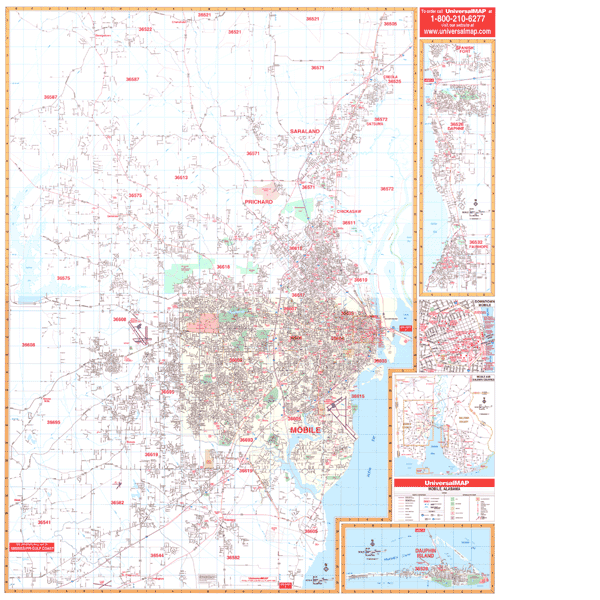
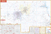
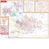
Mobile, AL
2009
3rd Edition
The Mobile, AL Wall Map measures 54"
x 64". This map offers up-to-date cartography with new streets
and changes. It has been printed in color with a markable and
washable laminated surface. Streets are indexed in a separate
book. This map's area of coverage ranges North to Georgetown,
Chunchula, and Creola; South to St. Elmo and Irvington; East to
Mobile County line, including Daphne and Fairhope in Baldwin
County (inset), and West to include Big Creek Lake and Rt. 11
(Wilmer Rd. and Newman Rd.) Insets for this wall map are of
Daughin Island, Daphne and Fairhope, Downtown Mobile
enlargement; Mobile/Baldwin Counties area map. Details found on
this map include all streets, post offices, hospitals,
railroads, mileage circles, airports, cemeteries, shopping
centers, water features, recreational parks, government
buildings, fire and police stations, educational facilities,
golf courses and country clubs, zip codes, and zip code
boundaries. Framing rails are included on top and bottom for
easy wall mounting.
|
|
 |
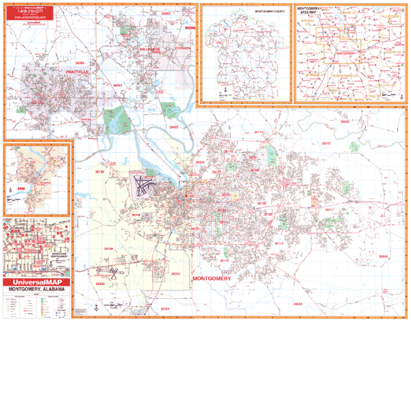
Montgomery/Montgomery CO, AL
2009 4th Edition
The Montgomery, AL Wall Map
published offers up-to-date cartography in complete street
detail with over 375 new streets. The map has been printed in
color on a laminated surface making it both markable and
washable. Also included is a comprehensive street index book.
The wall map's area of coverage ranges North to include all of
the city of Millbrook; South to the city limits of Montgomery
including I-65 exit #164; East to Pike Road, and West to include
the city of Prattville. Insets on this map are the city of
Wetumpka in Elmore County, Montgomery County area map, and a
Downtown Montgomery enlargement. This map also includes all
streets, post offices, hospitals, railroads, mileage circles,
zip code boundaries, airports, cemeteries, shopping centers,
water features, recreational parks, city limits and annexations,
government buildings, fire and police stations, educational
facilities. Framing rails are included on top and bottom for
easy wall mounting, measures 64" x 54". |
|
|