|
Wall Maps
- State, County & Cities - California
GeoMart
is rapidly expanding its on-line selection of wall maps. If you
don't find what you are looking for here, please give us a call at
800-248-6277. One of our customer service representative will be
happy to assist you in finding the right map for you.
Most Maps Usually Ship within 48 hours.
Laminated maps with the option of hanging
rails usually ship in 5 days
 |
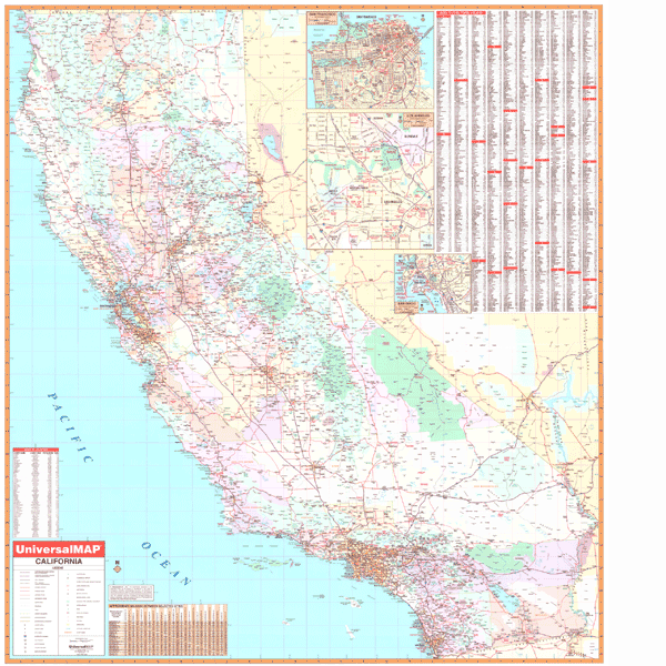
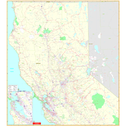
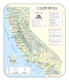
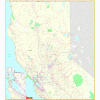
CALIFORNIA WALL MAP
2007
2nd edition This California Wall Map by Universal Map provides a laminated surface which is both markable and washable. It is indexed on the face of the map and measures 54 x 70. The data and details found on this map include all state and federal highways, cities and towns, major waterways, airports, hospitals, wildlife areas, state universities, state and national parks, military reservations, a mileage chart between major cities, county names and boundaries, color coded boundaries, and points of interest. Framing rails are
available on top and bottom for easy wall mounting. | |
 |
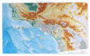
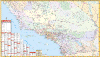
Raven California Map
From the spectacular volcano Mt Shasta in the
north through the Coastal Range, Cascade Mountains, and fertile
Central Valley to the San Francisco Bay, Sierra Nevada, the
beautiful Pacific Coast beaches and stunning deserts of the
southeast, our Raven California wall map presents a strikingly
beautiful view of the state. Elevations are represented by
color, and this, in combination with our relief shading
technique, gives the map a 3-dimensional look.
Raven California Map Dimensions:
Large 43" x 65", Small 34" x 49"
Raven California Map Scale:
Large 1:750,000 or 1" equals about 12 miles
Small 1:1 million or 1" equals about 16 miles |
|
 |
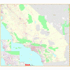
Raven Southern California Map
This intricately detailed map shows off Southern
California's spectacular land and seascapes. The warm blues of
the coastal waters are a perfect match for the rich earth tones
of the inland cliffs and mountains. Elevations are represented
by color, and this, in combination with our relief shading
technique, gives the map a 3-dimensional look.
Raven Southern California Map Dimensions: 33" x
64" (approx.)
Raven Southern California Map Scale: 1:375,000 or 1" equals
about 6 miles. |
|
 |
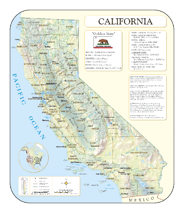
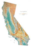
CALIFORNIA SHADED RELIEF MAP
The California Shaded Relief map by Universal Map measures 36 x 42 and is a full-color, topographical wall map. Statistical information on this map includes historical, anecdotal, and geographical. There is also an elevation scale measured in meters and feet and a distance scale measured in miles and kilometers. Identifies county boundaries. Shows state flag. Lists state motto, bird, flower, and tree, plus total area, population and origin of name. Its heavy laminated surface can be used with waterbased pens. |
Click Price to Add to Cart | | Laminated |
$31.95 |
|
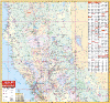 |
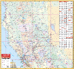
CALIFORNIA NORTH
2007 2nd edition
The 2002 edition Northern California Wall Map by Universal Map
covers approximately 40 counties, measures 54 by 54 inches, uses up-to-date
cartography, is printed in color, laminated, indexed on the map's face for
cities/counties, and shows color-coded counties. Coverage ranges north to the
state line; south to include San Jose; east to the Nevada state line including
Reno; and west to the Pacific Ocean. Details all state highways, state
universities, cities, towns, points of interest, longitude/latitude lines, all
federal highways, military installations, state/national parks, mileage charts,
county names/boundaries, major waterways, major airports, wildlife areas, and
mileage circles. Framing rails are included on top and bottom for easy wall
mounting. |
|
 |
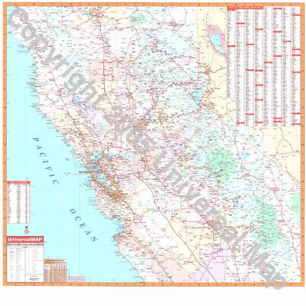
CALIFORNIA NORTH CENTRAL
2007 2nd edition
The first edition North Central California Region Wall Map
covers approximately 40 counties, measures 54 by 54 inches, uses up-to-date
cartography at a scale of 1 inch to approximately 6.6 miles, is indexed on the
face of the map, printed in color, and laminated. |
|
 |
NORTHERN CALIFORNIA VICINITY
2005 1st edition
The Northern California Vicinity Wall Map by Universal Map
measures 54"x60". The map includes up-to-date cartography at a scale of
1"=17,111' and is printed in color with a markable and washable laminated
surface. Cities are indexed and included in seperate index book and insets
include San Francisco/Oakland. Details include major streets and all highways,
zip codes and boundaries, latitude and longitude lines, county lines and names,
parks and amusement centers, water features, government buildings and federal
penitentiaries, military institutions and airports, and mileage circles. |
|
 |
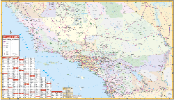
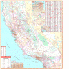
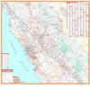
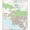
CALIFORNIA SOUTHERN
2007 2nd edition
The Southern California Wall Map by Universal Map measures 69
by 42 inches, provides lamination, and indexed for color-coded cities/counties
on the face of the map. Coverage includes Kern, Los Angeles, Orange, Riverside,
San Bernardino, San Diego, San Luis Obispo, Santa Barbara, and Ventura. Details
all streets/highways, mileage circles, shopping centers, water features,
recreational parks, section/range/township lines, government buildings,
fire/police stations, educational facilities, golf courses/country clubs, zip
codes/boundaries, airports, post offices, hospitals, railroads, cemeteries, and
latitude/longitude lines. Framing rails are included on top and bottom for easy
wall mounting. |
|
 |
SOUTHERN
CALIFORNIA VICINITY
2008 2nd edition
The Southern California Vicinity Wall Map by Universal Map
measures 60"x54". The map includes up-to-date cartography at a scale of
1"=41,000' and is printed in color with a markable and washable laminated
surface. Cities are indexed and included in separate index book. Insets include
Los Angeles and San Diego. Details include major streets and all highways, zip
codes and boundaries, latitude and longitude lines, county lines and names,
parks and amusement centers, water features, government buildings and federal
penitentiaries, military institutions and airports, and mileage circles. |
|
|
 |
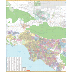
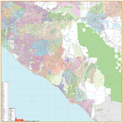
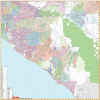
LOS ANGELES CA VICINITY
2005 1st edition
The Los Angeles, California and vicinity Wall Map
published by Universal Map measures 54” W x 64” H using up-to-date cartography
at a scale of 1” = 8,341 feet. Printed in color with a washable/markable-laminated
surface. Has hanging rails mounted top and bottom. Cities are indexed on the
face of the map. Area of Coverage: North: to Willow Springs and Lancaster;
South: includes Laguna Beach and Mission Viejo; East: to Corona and Ontario;
West: includes Fillmore and Malibu. Details include major streets/all highways,
zip codes/boundaries, latitude/longitude lines, county lines/names, parks/golf
course/amusement centers/stadiums, water features, government buildings/federal
penitentiaries, military installations/airports, hospitals, cemeteries, mileage
circles, and points of interest. |
|
 |
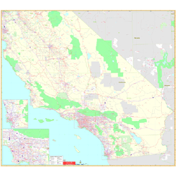
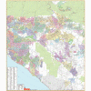
ORANGE COUNTY CA VICINITY
2005 1st edition
The Orange County
California Vicinity Wall Map by Universal Map includes up-to-date cartography at
a scale of 1"=4,164' and is printed in color with a markable and washable
laminated surface. Cities are indexed on face of the map. Detailes include major
streets and all highways, zip codes and boundaries, latitude and longitude
lines, county lines and names, parks, golf courses, amusement centers and
stadiums, water features, government buildings and federal penitentiaries,
military institutions and airports, hospitals and cemeteries, and mileage
circles. |
|
 |
SAN BERNARDINO - RIVERSIDE CA
VICINITY
2005 1st Edition
The 2005 San Bernardino/Riverside,
California and Vicinity Wall Map published by Universal Map measures 54” W x 62”
H using up-to-date cartography at a scale of 1” = 6,492 feet.
Printed in color with a markable/washable-laminated surface. Provides hanging
rails mounted top and bottom. Cities are indexed on the face of the map.
Area of coverage ranges:
* North: 50 miles North of San Bernardino;
* South: Includes San Clement and Pauma Valley;
* East: : to Hemet and Yucuipa;
* West: includes Seal Beach and El Monte.
Details include major streets/all highways, zip codes/boundaries,
latitude/longitude lines, county lines/names, parks/golf course/amusement
centers/stadiums, water features, government buildings/federal penitentiaries,
military installations/airports, hospitals, cemeteries, mileage circles, and
points of interest. |
|
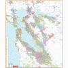 |
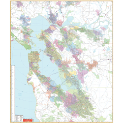
SAN FRANCISCO CA VICINITY
2005 1st edition
The San Francisco California Vicinity Wall Map by Universal
Map includes up-to-date cartography at a scale of 1"=6,667' and is printed in
color with a markable and washable laminated surface. Cities are indexed on the
face of the map. Details include major streets and all highways, zip codes and
boundaries, latitude and longitude lines, county lines and names, parks, golf
courses, amusement centers and stadiums, water features, government buildings
and federal penitentiaries, military institutions and airports, hospitals and
cemeteries, and mileage circles. |
|
|