|
Wall Maps
- State, County & Cities - Georgia
GeoMart
is rapidly expanding its on-line selection of wall maps. If you
don't find what you are looking for here, please give us a call at
800-248-6277. One of our customer service representative will be
happy to assist you in finding the right map for you.
Most Maps Usually Ship within 48
hours.
Laminated maps with the option of hanging
rails usually ship in 5 days
 |
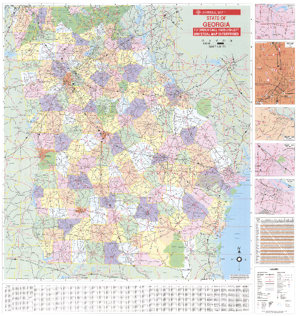
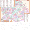
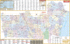
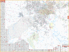
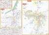
GEORGIA WALL MAP
2008
4th edition The special features found on the 2004 edition Georgia Wall Map by Universal Map are as follows: color coded counties, county names, all state highways, cities, state parks and wildlife areas, major waterways, all federal highways, cities and towns, military installations, major airports, state universities, and various points of interest. There is an inset map of Atlanta in more detail. The map also includes a mileage chart between major cities. This wall map is measures 60 W x 54 H and has up-to-date cartography. The map was printed in color and has been protected with a laminate finish which is both markable and washable. This map has been indexed on the face of the map.
Framing rails are available on top and bottom for easy wall mounting. | |
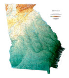 |
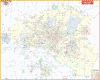
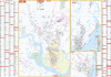
Raven Georgia Map
The state of Georgia lies between the
Chattahoochee and the Savannah Rivers, and the Blue Ridge
Mountains and the Atlantic Ocean. The plains, the hilly
piedmont, and even the Appalachian Plateau in the northwestern
corner are all depicted in delicate shades of brown and green,
with each color representing a different elevation. This, in
combination with our relief shading technique, gives the map a
3-dimensional look.
Raven Georgia Map Dimensions: 40" x
45" (approx.)
Raven Georgia Map Scale: 1:500,000 or 1" equals about 8 miles. |
|
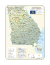 |
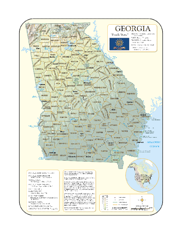
GEORGIA SHADED RELIEF MAP
The Georgia Shaded Relief Wall Map published by Universal Map measures 36 x 48 and is a full-color, topographical wall map. Statistical information on this map includes historical, anecdotal, and geographical. Identifies county boundaries. Shows state flag. Lists state motto, bird, flower, and tree, plus total area, population and origin of name. Its heavy laminated surface can be used with waterbased pens.
|
Click Price to Add to Cart | |
Laminated |
$31.95 |
|
 |
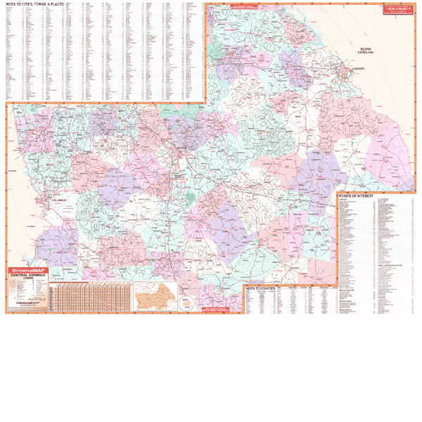
GEORGIA CENTRAL WALL MAP
2007
3rd edition The Central Georgia Region Wall Map by Universal Map measures 62” x 48” with up-to-date cartography at a scale of 1” = 3.50 miles. Area of coverage: North: Troup and Monroe Counties; Northeast: Oglethorpe and Lincoln Counties; South: Sumpter and Toombs Counties; East: South Carolina State line: West: Alabama State line. Special features show all 58 counties in Central Georgia. Printed in color with a markable and washable laminated surface with hanging rails. Streets indexed on the face of the map. | |
 |
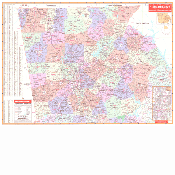
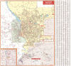
GEORGIA NORTH WALL MAP
2007 3rd edition The North Georgia Wall Map published by Universal Map measures 71 x 51 and is protected by a laminated surface making the map both markable and washable. The area of coverage runs North to the Tennessee/North Carolina state lines--approximately 80 miles north of Atlanta; South to include portions of Pike, Lamar, and Merriwether Counties; East to approximately 90 miles east of Atlanta to the South Carolina state line; and West to the Alabama state line. Special features include new interstate highway exit numbers, color coded counties--showing all 61 counties surrounding Atlanta, and a 50 to 90 mile radius of Atlanta. Details shown on this map are as follows: interstates, US highways, state highways, county roads, airports, shopping centers, colleges, hospitals, military installations, parks, water features, recreation areas, national forests, wildlife hunting areas, mileage circles, longitude and latitude lines, and other points of interest, plus a complete index.
Framing rails are available on top and bottom for easy wall mounting. | |
 |
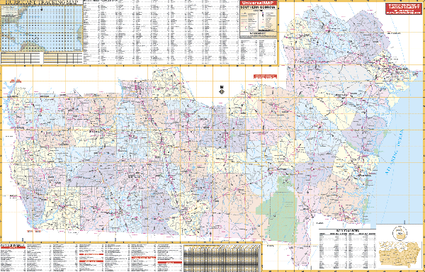
GEORGIA SOUTH WALL MAP
2007
2nd edition The South Georgia Area Wall Map by Universal Map measures 62 W x 42 H and is laminated making the map markable and washable. The map shows all 57 counties in southern Georgia with coverage as follows: North to Quitman, Lee, Crisp, Wilcox, and Jeff Davis Counties; Northeast to Chatham, Effingham, Bulloch, and Candler Counties; South to the Florida state line; East to the Atlantic Ocean; and West to the Alabama state line. Special features include color coded counties, a mileage chart between major cities, Interstate highway exit numbers, and a hurricane tracking chart. Details found on the map include: interstates, US and state highways, country roads, airports, longitude and latitude lines, colleges, hospitals, water features, recreation areas, military installations, parks and national forests, and miscellaneous points of interest.
Framing rails are available on top and bottom for easy wall mounting. | |
 |
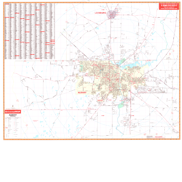
ALBANY WALL MAP
2007 4th edition The Albany, GA Wall Map by Universal Map has added approximately 500 new streets and changes. There is an inset map of Western Dougherty County. The special features and data contained on this map include all streets and highways, government buildings, zip codes and zip code boundaries, airports, golf courses and country clubs, water features, city limits, annexations, post offices, shopping centers, cemeteries, mileage circles, educational facilities, mobile home parks, hospitals, recreational parks, railroads, and points of interest, plus a complete index. This wall map measures 54 H x 65 W and is protected by a laminate surface which is markable and washable.
Framing rails are available on top and bottom for easy wall mounting. | |
 |
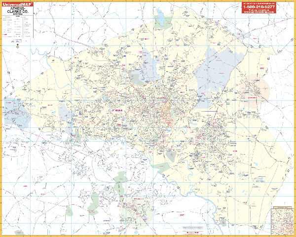
ATHENS WALL MAP
2009
4th edition The Athens, GA Wall Map by Universal Map provides up-to-date cartography in complete street detail with over 200 new streets and changes. This map has been printed in color and laminated making the surface both markable and washable. Street indexing appears in a separate book. This map's area of coverage ranges North: to the Jackson County line; South to include the city of Watkinsville; East to include the city of Winterville; and West to include the city of Bogart. Also included is an inset map of Downtown Athens. Details found with this map are as follows: airports, cemeteries, hospitals, railroads, post offices, longitude and latitude lines, all streets and highways, shopping centers, water features, recreational parks, mileage circles, school district lines, government buildings, fire and police stations, educational facilities, golf courses and country clubs, zip codes and boundaries, city limits and annexations, and miscellaneous points of interest.
Framing rails are available on top and bottom for easy wall mounting. 65"x54" | |
 |
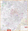
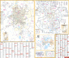
ATLANTA METRO WALL MAP
2007
2nd edition The Atlanta, GA Metropolitan Area by Universal Map provides expanded coverage 9 ½ miles further East than the Atlanta, GA Wall Map. Measuring 72” x 77”, it is illustrated in complete street detail, and contains up-to-date cartography with new streets and changes. Area of coverage: North: Alpharetta, Roswell, and Woodstock; South: Jonesboro, Stockbridge, Fairburn, and Union City; East: Lawrenceville, Snellville, and Conyers; West: Fairburn, Kennewaw, Marietta, and Austell. Insets: Palmetto and Downtown Atlanta. A protective laminate finish can be used with waterbased pens.
Framing rails are available on top and bottom for easy wall mounting. | |
 |
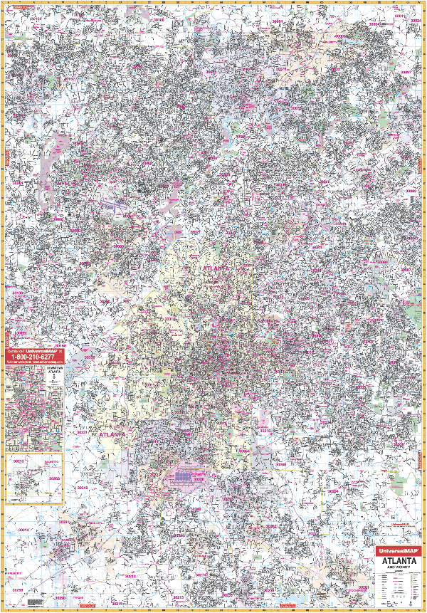
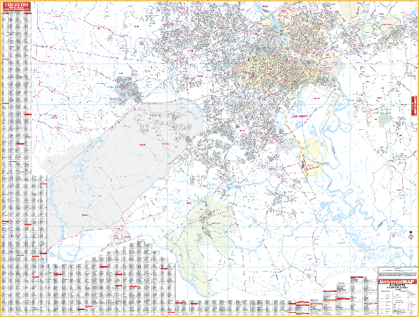
ATLANTA WALL MAP
2007 5th edition The Atlanta, GA Wall Map by Universal Map measures 54” x 77”. The area of cover ranges: North: Alpharetta, Roswell, and Woodstock; South: Jonesboro, Stockbridge, Fairburn, and Union City; East: Stone Mountain, Norcross, Berkeley Lake, and most of Duluth; West: Fairburn, Kennesaw, Marietta, and Austell. Completely updated, its laminated surface makes the map markable and washable. Street indexing is provided in a separate book. Top and bottom framing rails are
available for easy wall mounting. | |
 |
AUGUSTA WALL MAP
2007
4th edition The
Augusta, GA Wall Map by Universal Map measures 69” x 54.” Provides complete street detail at and up-to-date cartography with new streets and changes. Coverage: North: includes Maddox and North Augusta; South: to the Burke County line; East: includes Burnettown; West: includes Harlem and Blyth.
Framing rails are available on top and bottom for easy wall mounting. Protected by laminated surface that is markable/washable.
Framing rails are available on top and bottom for easy wall mounting. | |
 |
BRUNSWICK WALL MAP
2002 1st edition The Brunswick, GA Wall Map by Universal Map includes St. Simons Island and Jeckyll Island Protected by a markable and washable laminated surface, framing rails
are available on top and bottom for easy wall hanging. Streets are indexed on the face of the map. The area of coverage is divided into three sections. Section I: Brunswick North to Hofwyl-Broadfield Plantation; South to South Brunswick River and Georgia Coast Guard Station; East to Little River; West to Twin Rivers and South Port. Section II: St. Simons Island runs North to Hampton Plantations; South to Lighthouse; East to Ocean Forest Golf Course; and West to Frederica River. Section III: Jekyll Island with Glynn County inset. Other points of interest include government buildings, airports, zip codes and boundaries, golf courses and country clubs, water features, post offices, shopping centers, recreational parks, city limits and annexations, educational facilities, fire and police stations, hospitals, railroads, subdivision names, cemeteries, and mileage circles.
64"x54" | |
 |
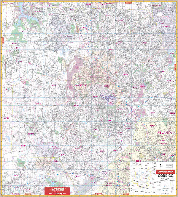
COBB COUNTY WALL MAP
2007 3rd edition The Cobb County, GA Wall Map by Universal Map includes a laminated surface making the wall map markable and washable, along with street indexing in a separate book. The area of coverage for this wall map is as follows: Cobb County and adjacent area including Austell, Blackwells, Bolton, Clarksdale, Elizabeth, Fair Oaks, East Marietta, Floyd, Kennesaw, Marbleton, Marietta, Noonday, Powder Springs, Smyrna, South Cobb, Vinings, and Westoak; Lithia Springs and portion of Douglasville in Douglas County; approximately 2-4 miles into Atlanta, including I-75 and I-85 in Fulton County; North to the Cobb/Cherokee County Line; South to the Cobb/Fulton/Douglas County line; East to the Cobb/Fulton County line; and West to the Cobb/Paulding County line. Details and information included on this wall map includes all streets, all highways, educational facilities, post offices, government buildings, fire and police stations, hospitals, shopping centers, land lot numbers, airports, cemeteries, railroads, water features, golf courses and country clubs, mileage circles, recreational parks, zip codes and boundaries, city limits and annexations, and other miscellaneous points of interest.
Framing rails are available on top and bottom for easy wall mounting. 54" x 60" | |
 |
COLUMBUS/PHENIX CITY WALL MAP
2008
3rd edition The Columbus, GA and Phenix City, AL Wall Map by Universal Map offers complete street detail of the area. Boundaries on this wall map are as follows: North To Muscogee County Line; South to include Lawson Army Field; East to include Ft. Benning Military Reservation; and West to include Ladonia. The map includes an 50 mile radius area map, plus educational facilities, government buildings, shopping centers, hospitals, zip codes, post offices, fire and police stations, airports, cemeteries, recreational parks, golf and country clubs, points of interest, city limits and annexations, railroads, mileage circles, and water features. In addition, there is a complete index. The map is is protected with a laminate finish, which is both markable and washable.
Framing rails are available on top and bottom for easy wall mounting. 64" x61" | |
 |
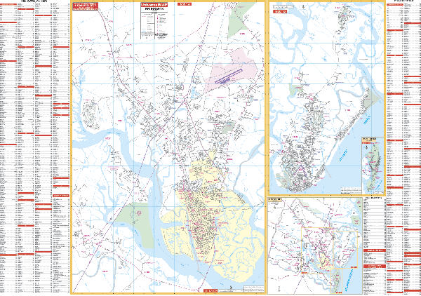
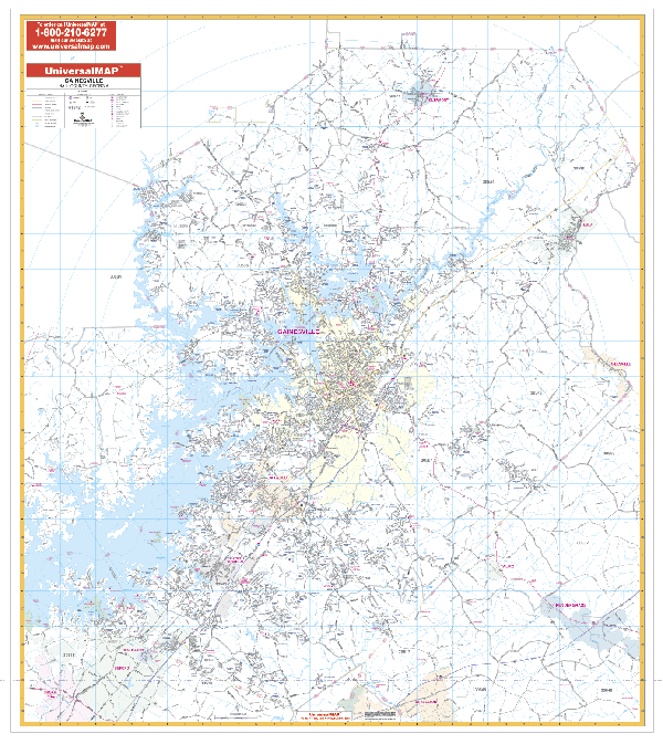
GAINESVILLE/HALL COUNTY WALL MAP
2006
2nd edition The Gainesville, GA Wall Map by Universal Map measures 54 x 72 and features complete street detail. Other features include up-to-date cartography with new streets and changes, color, and lamination making the map markable and washable. The area of coverage ranges North to the White County line; South to the Jackson and Gwinnett County lines; East to Pendergrass, Lula, and Gillsville; and West to the city of Sugar Hill, and the Lumpton County line. Highlights
include airports, cemeteries, hospitals, railroads, post offices, longitude and latitude lines, all streets and highways, shopping centers, water features, recreational parks, mileage circles, school district lines, government buildings, fire and police stations, educational facilities, golf courses and country clubs, zip codes and boundaries, city limits and annexations, and miscellaneous points of interest.
Framing rails are available on top and bottom for easy wall mounting. | |
 |
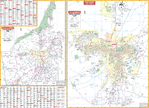
ROME/FLOYD COUNTY WALL MAP
2001
2nd edition The Rome and Floyd County, GA Wall Map by Universal Map provides up-to-date cartography in complete street detail. This map is protected with a laminate finish making it markable and washable. The streets have been indexed on the face of the map which measures 66 W x 49 H. The area of coverage includes all of Floyd County with the following boundaries: North-to include Richard B. Russell Airport; South-to include Paris Lake and the proposed new
southern by-pass; East-to Woodcliff Estates; and West-to Woods Road. There is an inset map of Floyd County. Other points of interest highlighted are government buildings, airports, golf courses and country clubs, railroads, zip codes and zip code boundaries, shopping centers, water features, recreational parks, cemeteries, educational facilities, hospitals, post offices, city limits and annexations, fire and police stations.
Framing rails are available on top and bottom for easy wall mounting. | |
 |
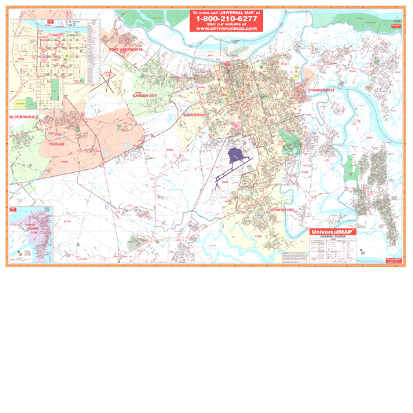
SAVANNAH WALL MAP
2009 5th edition The Savannah, GA Wall Map by Universal Map measures 74 x 50 and has added approximately 550 new streets and changes. Boundaries include North to South Carolina state line; South to Middle Marsh Island, Steadman Island, State Road 204 and I-95 Interchange; East to Skidaway Island and Wilmington Island; and West to Pooler and Bloomingdale. Other data includes educational facilities, government buildings, shopping centers, hospitals, zip codes and boundaries, post offices, fire and police stations, airports, cemeteries, recreational parks, golf and country clubs, points of interest, city limits and annexations, railroads, mileage circles, water features, range, township and section lines, block numbers, and longitude/ latitude lines. The map is protected with a laminate finish, which is both markable and washable. In addition, for your convenience, the map is indexed in a separate book.
Framing rails are available on top and bottom for easy wall mounting. | |
 |
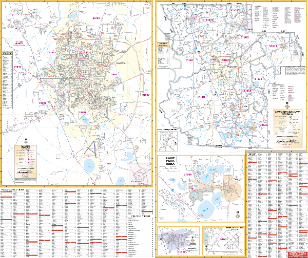
VALDOSTA WALL MAP-2ND EDITION
2009
3rd edition The Valdosta, GA Wall Map by Universal Map measures 64 x 46 and is in complete street detail. Offered is up-to-date cartography with new streets and changes. This map is printed in color with a markable and washable laminated surface. Streets are indexed in a separate book. This map's area of coverage ranges North to Stafford Wright Road; South to 2 miles south of Valdosta Airport; East to Moore Crossing; and West to Lake Eileen; Included are insets to Lowndes County, Lake Park, Hahira, and Moody AFB. The special features and data contained on this map are as follows: all streets, all highways, educational facilities, government buildings, shopping centers, hospitals, airports, recreational parks, post offices, golf and country clubs, points of interest, city limits and annexations, railroads, mileage circles, water features, cemeteries, fire and police stations, zip code and boundaries.
Framing rails are available on top and bottom for easy wall mounting. | |
|