|
Wall Maps
- State, County & Cities
GeoMart
is rapidly expanding its on-line selection of wall maps. If you
don't find what you are looking for here, please give us a call at
800-248-6277. One of our customer service representative will be
happy to assist you in finding the right map for you.
Most Maps Usually Ship within 48 hours.
Laminated maps with the option of hanging
rails usually ship in 5 days
 |
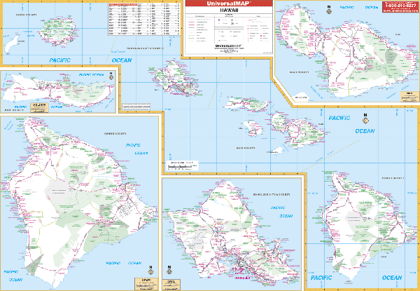
HAWAII WALL MAP
2004 1st edition The Hawaii Wall Map by Universal Map measures 58” x 42” and provides up-to-date cartography.
Hanging rails are available mounted top and bottom. Cities and counties are indexed on the face of the map. Includes inset maps of the following islands in more detail: Molokai at a scale of 1” = 4.50 miles; Hawaii at a scale of 1” = 6.75 miles; Oahu at a scale of 1” = 4.50 miles; Maui at a scale of 1” = 4.50 miles. | |
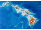 |
Raven Hawaii Map
This stunning map of Hawaii
displays the eight main islands, each of which is actually a
submerged volcano. The ocean depths are shown in rich shades of
blue. Elevations are represented by color, and this, in
combination with our relief shading technique, gives the map a
3-dimensional look.Raven
Hawaii Map Dimensions: 30" x 42" (approx.)
Raven Hawaii Map Scale: 1:750,000 or 1" equals about 12 miles |
|
 |
HAWAII SHADED RELIEF MAP
The Hawaii Shaded Relief Wall Map by Universal Map is a full-color, topographical wall map. Statistical information on this map includes historical, anecdotal, and geographical. Identifies county boundaries. Shows state flag. Lists state motto, bird, flower, and tree, plus total area, population and origin of name. Its heavy laminated surface can be used with waterbased pens. This map measures 46 by 36. |
Click Price to Add to Cart | |
Laminated |
$31.95 |
|
|