|
Wall Maps
- State, County & Cities - Idaho
GeoMart
is rapidly expanding its on-line selection of wall maps. If you
don't find what you are looking for here, please give us a call at
800-248-6277. One of our customer service representative will be
happy to assist you in finding the right map for you.
Most Maps Usually Ship within 48 hours.
Laminated maps with the option of hanging
rails usually ship in 5 days
 |
IDAHO WALL MAP 2005
2nd edition The Idaho Wall Map by Universal Map measures 42” x 65” and contains up-to-date cartography at a scale of 1” = 8.50 miles. Printed in color with a markable and washable laminated surface with hanging rails
available on top and bottom. Cities and counties are indexed on the face of the map. Features include color-coded counties and a mileage chart between major cities. Also includes all state highways, all federal highways, secondary roads, cities and towns, major airports, and more. | |
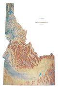 |
Raven Idaho Map
From the beautiful Pend Oreille Lake in the
Panhandle to the extensive Snake River Plain in the south, the
state of Idaho is home to 80 mountain ranges and the spectacular
Snake River Gorge. Elevations are represented by color, and
this, in combination with our relief shading technique, gives
the map a 3-dimensional look.
Raven Idaho Map Dimensions: 42" x
65" (approx.)
Raven Idaho Map Scale: 1:500,000 or 1" equals about 8 miles |
|
 |
IDAHO SHADED RELIEF MAP The Idaho Shaded Relief Wall Map published by Universal Map is a full-color, topographical wall map. Statistical information on this map includes historical, anecdotal, and geographical. Identifies county boundaries. Shows state flag. Lists state motto, bird, flower, and tree, plus total area, population and origin of name. Its heavy laminated surface can be used with waterbased pens. This map measures 36 x 48 inches. |
Click Price to Add to Cart | | Laminated | $31.95 |
|
 |
BOISE WALL MAP 2009 4th Edition
The
Boise, Idaho Wall Map by Universal Map provides up-to-date cartography in
complete street detail with over 350 new streets and changes. Printed in color
and laminated making the surface markable and washable. Measures 6' 5" W x 4' 6"
H and is indexed in a separate book. The area of coverage ranges: North:
to include the cities of Eagle, Middleton, and Star; South: to the Snake River
Birds of Prey area and also Kuna-Mora Road; East: to Exit #64 of I-84 and to the
Barber Pool Reserve; West: to include the city of Caldwell and the Deer Flat
National Wildlife Refuge (Lake Lowell).
The map contains an inset of downtown Boise. Special features, data, and
information are: airports, cemeteries, hospitals, railroads, post offices,
subdivision names, all streets and highways, shopping centers, water features,
recreational parks, mileage circles, mobile home parks, government buildings,
fire and police stations, educational facilities, golf courses and country
clubs, zip codes and zip code boundaries, longitude and latitude lines, and
points of interest.
| |
 |
POCATELLO WALL MAP 2002 1st edition The Pocatello, ID Wall Map by Universal Map measures 43 W x 54H, and is protected by a markable and washable laminate surface. The map provides up-to-date cartography with new streets and changes and has indexing on the face of the map. The area of coverage ranges North to Fort Hall Indian Reservation; South to the city of Portneuf and Caribou National Forest; East to the Camelback Mountain and Timberline Drive; and West to Fort Hall Indian Reservation. Also highlights government buildings, airports, golf courses and country clubs, railroads, zip codes and zip code boundaries, shopping centers, water features, recreational parks, cemeteries, educational facilities, hospitals, post offices, city limits and annexations, longitude and latitude lines, range/township/section lines, mileage circles, fire and police stations, and miscellaneous points of interest. Framing rails are
available on top and bottom for easy wall mounting. | |
|