|
Wall Maps
- State, County & Cities - Maine
GeoMart
is rapidly expanding its on-line selection of wall maps. If you
don't find what you are looking for here, please give us a call at
800-248-6277. One of our customer service representative will be
happy to assist you in finding the right map for you.
Most Maps Usually Ship within 48 hours.
Laminated maps with the option of hanging
rails usually ship in 5 days
 |
MAINE WALL MAP
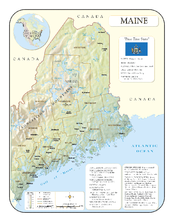
2001 1st edition The Maine Wall Map by Universal Map is protected by a laminated surface that is both markable and washable. Indexing is printed on the face of the map, which measures 3' 4 W x 5' H. The area of coverage ranges North to the Canadian Border, South to the Atlantic Ocean, East to the Canadian border and the Atlantic Ocean, and West to the New Hampshire state line. Special features provided are insets of Portland, Augusta, and Bangor-Brewer. Details include state and federal highways, cities and towns, major waterways, airports, ski areas, state universities, state and national parks, wildlife areas, military installations, county names, and points of interest. | |
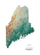 |
Raven Maine Map
The Atlantic coast of Maine has over 400 islands
which were created when a great ice sheet compacted hills,
forcing them down into the water so that only the tops of the
hills remain. West of the coastline is fertile farmland and
beautiful pine forests. The Maine White Mountains contain
spectacular Mount Katahdin. Elevations are represented by color,
and this, in combination with our relief shading technique,
gives the map a 3-dimensional look.
Raven Maine Map Dimensions: 36" x
48" (approx.)
Raven Maine Map Scale: 1:500,000 or 1" equals about 8 miles |
|
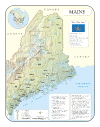 |
MAINE SHADED RELIEF MAP
The Maine Shaded Relief Wall Map by Universal Map measures 36 W x 46 H and is a full-color, topographical wall map. There is an inset map of North America showing the relative position of the state. Included is geographical, historical, and anecdotal information about Maryland. Also provided with this map are the major cities, counties, national capital, state capital, county seats, and state and county boundaries. There is a distance scale calibrated in miles and kilometers, and identifies county boundaries. State facts include flag, motto, bird, flower, and tree, plus total area, population and origin of name. Its heavy laminated surface can be used with waterbased pens. |
Click Price to Add to Cart | | Laminated |
$31.95 |
|
|