|
Wall Maps
- State, County & Cities - Montana
GeoMart
is rapidly expanding its on-line selection of wall maps. If you
don't find what you are looking for here, please give us a call at
800-248-6277. One of our customer service representative will be
happy to assist you in finding the right map for you.
Most Maps Usually Ship within 48 hours.
Laminated maps with the option of hanging
rails usually ship in 5 days
 |
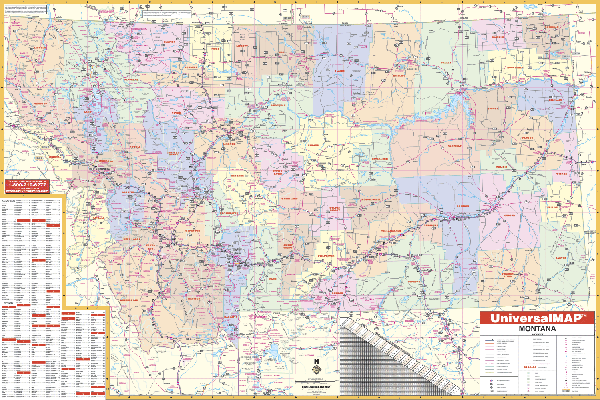
MONTANA WALL MAP
2003 1st edition The Montana Wall Map measures 63” x 42” and provides up-to-date cartography at a scale of 1” = 8.50 miles. Printed in color with a markable and washable laminated surface with
available hanging rails mounted top and bottom. Cities and counties are indexed on the face of the map. Special features include color coded counties and a mileage chart between major cities. Details include all state highways, all federal highways, secondary roads, cities and towns, and more. | |
 |
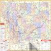
Raven Montana Map
The Big Sky state has two
distinct geographic regions. In the west are the Rocky
Mountains, with over 50 named mountain ranges and Flathead Lake.
In the east are the Great Plains and Fort Peck Reservoir. The
exquisite Missouri and Yellowstone Rivers run through both
regions. Elevations are represented by color, and this, in
combination with our relief shading technique, gives the map a
3-dimensional look.
Raven Montana Map Dimensions: 41" x 64" (approx.)
Raven Montana Map Scale: 1:600,000 or 1" equals about 10 miles |
|
 |
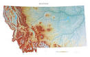
MONTANA SHADED RELIEF MAP
The Montana Shaded Relief Wall Map by Universal Map measures 48 W x 36 H and is a full-color, topographical wall map. There is an inset map of North America showing the relative position of the state. Included is geographical, historical, and anecdotal information about Maryland. Also provided with this map are the major cities, counties, national capital, state capital, county seats, and state and county boundaries. There is a distance scale calibrated in miles and kilometers, and identifies county boundaries. State facts include flag, motto, bird, flower, and tree, plus total area, population and origin of name. Its heavy laminated surface can be used with waterbased pens. |
Click Price to Add to Cart | | Laminated |
$31.95 |
|
|