|
Wall Maps
- State, County & Cities - North Dakota
GeoMart
is rapidly expanding its on-line selection of wall maps. If you
don't find what you are looking for here, please give us a call at
800-248-6277. One of our customer service representative will be
happy to assist you in finding the right map for you.
Most Maps Usually Ship within 48 hours.
Laminated maps with the option of hanging
rails usually ship in 5 days
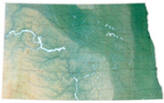 |
Raven North Dakota Map
The impressive Badlands of the southwest give way
to the Great Plains and the beautiful Missouri River. Going east
toward the fertile Red River Valley, you'll find a prairie
dotted with hills, valleys and lakes. Elevations are represented
by color, and this, in combination with our relief shading
technique, gives the map a 3-dimensional look.
Raven North Dakota Map Dimensions: 35" x 51" (approx.)
Raven North Dakota Map Scale: 1:500,000 or 1" equals about 8
miles |
|
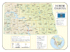 |
NORTH DAKOTA SHADED RELIEF MAP
The North Dakota Shaded Relief Wall Map by Universal Map measures 48 W x 36 H and is a full-color, topographical wall map. The map's lamination makes the map able to be marked on and wiped off easily. There is an inset map of North America showing the relative position of the state. Included is geographical, historical, and anecdotal information about Maryland. Also provided with this map are the major cities, counties, national capital, state capital, county seats, and state and county boundaries. There is a distance scale calibrated in miles and kilometers, and identifies county boundaries. State facts include flag, motto, bird, flower, and tree, plus total area, population and origin of name. |
Click Price to Add to Cart | | Laminated |
$31.95 |
|
|


