|
Wall Maps
- State, County & Cities - New Mexico
GeoMart
is rapidly expanding its on-line selection of wall maps. If you
don't find what you are looking for here, please give us a call at
800-248-6277. One of our customer service representative will be
happy to assist you in finding the right map for you.
Most Maps Usually Ship within 48 hours.
Laminated maps with the option of hanging
rails usually ship in 5 days
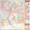 |
NEW MEXICO WALL MAP
2004
2nd edition The New Mexico Wall Map by Universal Map includes color coded counties, all state and federal highways, police, state universities, state parks, major waterways, cities, wildlife areas, various points of interest, exit numbers, major airports, towns, military installations, county names and boundaries, and ski resort areas, plus a comprehensive index. This map measures 48 W x 50 H and is protected with a laminate finish which is both markable and washable.
Framing rails are available on top and bottom for easy wall mounting. | |
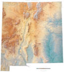 |
Raven New Mexico Map
The Rio Grande River and the Sangre de Cristo
Mountains dominate the landscape of this beautiful southwestern
state, famous for its towns like Taos, Los Alamos, Roswell, Las
Cruces, and Albuquerque. The Pecos River has cut dramatic
canyons in the eastern plateau. Elevations are represented by
color, and this, in combination with our relief shading
technique, gives the map a 3-dimensional look.
Raven New Mexico Map Dimensions: 45" x 52" (approx.)
Raven New Mexico Map Scale: 1:550,000 or 1" equals about 8 1/2
miles |
|
 |
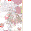
NEW MEXICO SHADED RELIEF MAP
The New Mexico Shaded Relief Wall Map by Universal Map measures 36 W x 48 H and is a full-color, topographical wall map. The map's lamination makes the map able to be marked on and wiped off easily. Statistical information on this map includes historical, anecdotal, and geographical. There is also an elevation scale measured in meters and feet and a distance scale measured in miles and kilometers. Identifies county boundaries. Shows state flag. Lists state motto, bird, flower, and tree, plus total area, population and origin of name. Its heavy laminated surface can be used with water based pens. |
Click Price to Add to Cart | | Laminated |
$31.95 |
|
 |
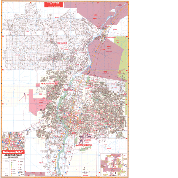
ALBUQUERQUE WALL MAP-
2009 5th edition The Albuquerque, NM Wall Map by Universal Map offers up-to-date cartography with over 800 new streets and changes, and is protected with a markable laminated finish. Street indexing appears in a separate book. This area of coverage ranges North to include the Rio Rancho area and cities of Bernalillo and El Llanito; South to Exit #213e of SR314 and Exit #215 of I-25 at Los Padilas; East to Cibola National Forest and eastern city limits of Albuquerque; and West to include the entire Rio Rancho platted area to Exit #149 of I-40 and Central Ave (SR 333) and the Double Eagle II Airport. Insets include Downtown Albuquerque and the University of New Mexico campus. Points of interest include airports, cemeteries, hospitals, railroads, post offices, all streets and highways, shopping centers, water features, recreational parks, mileage circles, longitude and latitude lines, government buildings, fire and police stations, educational facilities, golf courses and country clubs, zip codes and boundaries, city limits and annexations.
Framing rails are available on top and bottom for easy wall mounting. 54" x 77" | |
|