|
Wall Maps
- State, County & Cities - New York
GeoMart
is rapidly expanding its on-line selection of wall maps. If you
don't find what you are looking for here, please give us a call at
800-248-6277. One of our customer service representative will be
happy to assist you in finding the right map for you.
Most Maps Usually Ship within 48 hours.
Laminated maps with the option of hanging
rails usually ship in 5 days
 |
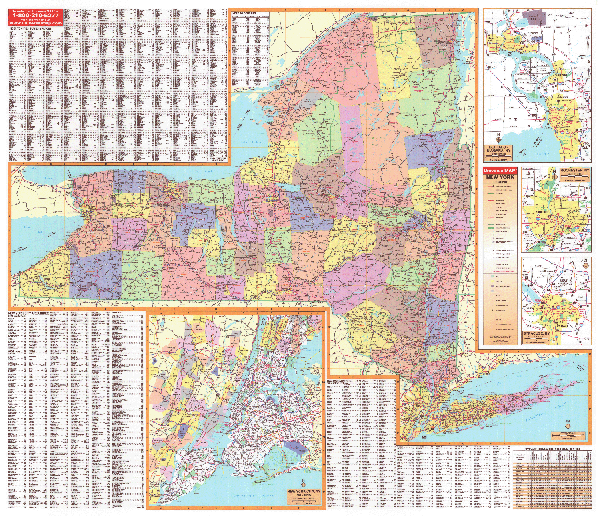
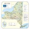
NEW YORK STATE WALL MAP
2006 3rd edition The New York State Wall Map by Universal Map includes all state and federal highways, major waterways, military installations, state parks, major airports, points of interest, state universities, cities, towns, and wildlife areas. Special features for this map are color-coded counties, a mileage chart between major cities, and inset maps of New York City and Manhattan, plus a comprehensive index. This Wall Map measures 60 W x 64 H and is protected with a laminate finish which is both markable and washable.
Framing rails are available on top and bottom for easy wall mounting. | |
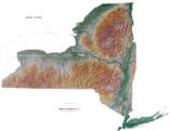 |
Raven New York Map
From Lake Erie and Lake Ontario in the north to
Montauk Point on the tip of Long Island, New York is incredibly
diverse. Points of interest include the Adirondack Mountains,
the Finger Lakes, the Catskill Mountains, and the historic
Hudson River. Elevations are represented by color, and this, in
combination with our relief shading technique, gives the map a
3-dimensional look.
Raven New York Map Dimensions: 43" x 59" (approx.)
Raven New York Map Scale: 1:500,000 or 1" equals about 8 miles. |
|
 |
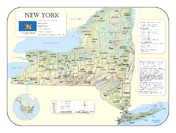
NEW YORK SHADED RELIEF MAP
The New York Shaded Relief Wall Map by Universal Map measures 48 W x 36 H and is a full-color, topographical wall map. Statistical information on this map includes historical, anecdotal, and geographical. There is also an elevation scale measured in meters and feet and a distance scale measured in miles and kilometers. Identifies county boundaries. Shows state flag. Lists state motto, bird, flower, and tree, plus total area, population and origin of name. Its heavy laminated surface can be used with waterbased pens. |
Click Price to Add to Cart | | Laminated |
$31.95 |
|
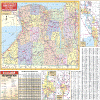 |
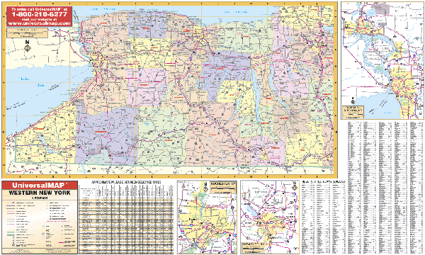
NEW YORK WESTERN STATE WALL MAP
2006
2nd edition The New York West Wall Map by Universal Map includes the 22 counties of western New York state. The map's area of coverage ranges North to Lake Ontario; South to the Pennsylvania State line; East to include Syracuse, and West to Lake Erie. The special features and data contained on this map are all state and federal highways, police, towns, military installations, major waterways, state police posts, state universities, state parks, major airports, cities, wildlife areas, county names and boundaries, a mileage chart between major cities, and various points of interest. There are insets of major cities in more detail. These include Buffalo, Rochester, and Syracuse. This map measures 66 x 40 and is protected by a laminate finish which is markable and washable. The map is indexed on the face of the map.
Framing rails are available on top and bottom for easy wall mounting. | |
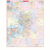 |
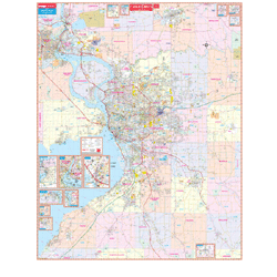
BUFFALO WALL MAP
2005
2nd edition The Buffalo, NY Wall Map by Universal Map ranges North to Lockport and Lewiston in Niagara County; South to North Collins; East to Akron and Alden; and West to Fort Erie Grand Island, Niagara Falls, and the Chippawa Power Canal. Insets for this map include Niagara Falls and Downtown Buffalo, the remainder of Erie County including the cities and towns of Collins, Gowanda and Springville, and the remainder of Niagara County including Barker, Middleport, Newfane, Olcott, Niagara on the Lake, Youngstown, and Wilson. Other points of interest include all streets and highways, educational facilities, government buildings, zip codes and boundaries, cemeteries, points of interest, city limits and annexations, post offices, shopping centers, recreational parks, railroads, fire and police stations, hospitals, golf courses and country clubs, and mileage circles. This map measures 5 1/2' x 6 1/2' and is protected by a markable laminate surface. Indexing for the map appears in a separate book.
Framing rails are available on top and bottom for easy wall mounting. | |
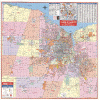 |
ROCHESTER WALL MAP
2008
3ed edition The Rochester, NY Wall Map by Universal Map has added approximately 550 new streets and changes. The boundaries include North to Lake Ontario; South to Livingston County Line; East to Wayne County Line; and West to Orleans County Line. There is a map inset of Downtown Rochester. The special features and data contained on this map are as follows: all streets, all highways, educational facilities, government buildings, shopping centers, hospitals, airports, recreational parks, post offices, golf courses and country clubs, points of interest, city limits and annexations, railroads, cemeteries,
fire and police stations, township names, zip codes and boundaries. The map is protected with a laminate finish, which is both markable and washable. In addition, for your convenience, the map is indexed in a separate book.
Framing rails are available on top and bottom for easy wall mounting. 64" x 46" | |
|