|
Wall Maps
- State, County & Cities - Oklahoma
GeoMart
is rapidly expanding its on-line selection of wall maps. If you
don't find what you are looking for here, please give us a call at
800-248-6277. One of our customer service representative will be
happy to assist you in finding the right map for you.
Most Maps Usually Ship within 48 hours.
Laminated maps with the option of hanging
rails usually ship in 5 days
 |
OKLAHOMA WALL MAP
2008
3rd edition The Oklahoma Wall Map by Universal Map includes all state and federal highways, major waterways, towns, military installations, major airports, state universities, cities, state parks, wildlife areas, mileage chart, and points of interest. Featured are color coded counties and insets of Tulsa and Oklahoma City. This map measure 56 H x 36 W and is lithographed in eight colors. The map has been protected by a laminate surface which is both markable and washable. Also, the map has been indexed on the face of the map.
Framing rails are available on top and bottom for easy wall mounting. | |
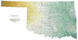 |
Raven Oklahoma Map
The Arkansas, Canadian, and Red Rivers flow
through this land of fertile plains, blackjack and post oak
forests, large grassy regions, and low hills. Elevations are
represented by color, and this, in combination with our relief
shading technique, gives the map a 3-dimensional look.
Raven Oklahoma Map Dimensions: 35" x 67" (approx.)
Raven Oklahoma Map Scale: 1:500,000 or 1" equals about 8 miles |
|
 |
OKLAHOMA SHADED RELIEF MAP
2000 1st edition The Oklahoma Shaded Relief Wall Map by Universal Map is a full-color, topographical wall map. Statistical information on this map includes historical, anecdotal, and geographical. There is also an elevation scale measured in meters and feet and a distance scale measured in miles and kilometers. Identifies county boundaries. Shows state flag. Lists state motto, bird, flower, and tree, plus total area, population and origin of name. Its heavy laminated surface can be used with waterbased pens.
48" x 36" |
Click Price to Add to Cart | | Laminated |
$31.95 |
|
 |
BARTLESVILLE WALL MAP
2003
2nd edition The Bartlesville, OK Wall Map by Universal Map provides up-to-date cartography showing the new streets and changes. It is protected by a laminated surface that is both markable and washable. The street index appears on the face of the map. Measuring 4' 2 x 5' 6, coverage ranges North to include Dewey and the Washington County Softball Field; South to two miles South of Rice Creek Road; East to city limits of Bartlesville; and West to Bartlesville Municipal Airport. Also included are post offices, hospitals, railroads, mileage circles, airports, cemeteries, shopping centers, water features, recreational parks, government buildings, fire and police stations, educational facilities, golf courses, and country clubs.
Framing rails are available on top and bottom for easy wall mounting. | |
 |
OKLAHOMA CITY WALL MAP
2007 5th edition The Oklahoma City, OK Wall Map by Universal Map offers up-to-date cartography with new streets and changes. Includes complete street detail and lamination that is both markable and washable, street indexing in a separate book. Measures 60 W x 73 H.
Framing rails are available on top and bottom for easy wall mounting. | |
 |
TULSA WALL MAP
2008 6th edition
The 3rd edition of the Tulsa, OK Wall Map by Universal Map measures 60 x 60.
Illustrated with complete street detail, its protective laminate surface can be
used with water based pens. A separate index book is provided. Framing rails are
available on top and bottom for easy wall mounting. | |
|


