|
Wall Maps
- State, County & Cities - Virginia
GeoMart
is rapidly expanding its on-line selection of wall maps. If you
don't find what you are looking for here, please give us a call at
800-248-6277. One of our customer service representative will be
happy to assist you in finding the right map for you.
Most Maps Usually Ship within 48 hours.
Laminated maps with the option of hanging
rails usually ship in 5 days
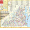 |
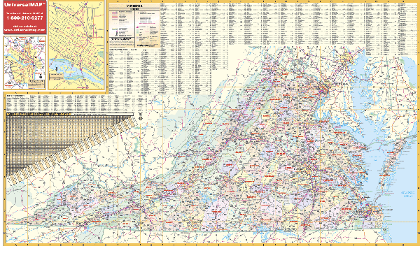
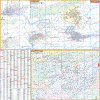
VIRGINIA WALL MAP
2009
3rd edition The Virginia Wall Map by Universal Map measures 36 W x 56 H and includes the following: all state highways, all federal highways, cities, major waterways, major airports, state parks, towns, state universities, wildlife areas, military installations, points of interest, and a mileage chart. The map includes one inset of Richmond. Special Features: Color Coded Counties. The map is protected with a laminate, which is both markable and washable. In addition, for your convenience, this map is indexed on the face of the map.
Framing rails are available on top and bottom for easy wall mounting. | |
 |
Raven VA, MD, DE & D.C. Map
This regional map is centered on the Chesapeake
Bay area. Elevations are represented by color, and this, in
combination with our relief shading technique, gives the map a
3-dimensional look.
Raven VA, MD, DE & D.C. Map
Dimensions: 34" x 65" (approx.)
Raven VA, MD, DE & D.C. Map Scale: 1:500,000 or 1" equals
about 8 miles |
|
 |
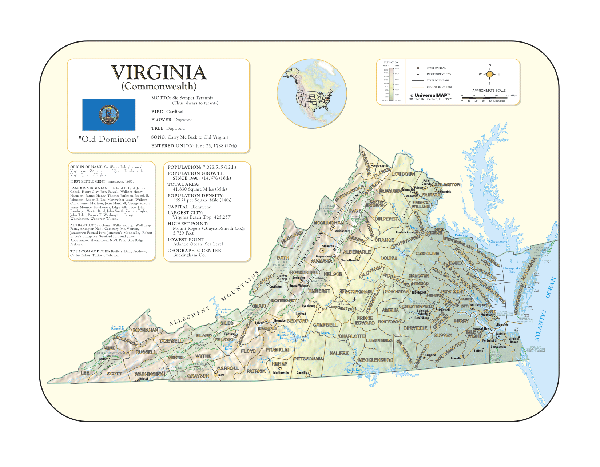
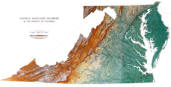
VIRGINIA SHADED RELIEF MAP
The Virginia Shaded Relief Wall Map by Universal Map is a full-color, topographical wall map. Statistical information on this map includes historical, anecdotal, and geographical. There is also an elevation scale measured in meters and feet and a distance scale measured in miles and kilometers. Identifies county boundaries. Shows state flag. Lists state motto, bird, flower, and tree, plus total area, population and origin of name. Its heavy laminated surface can be used with waterbased pens.
48" x 36" |
Click Price to Add to Cart | | Laminated |
$31.95 |
|
 |
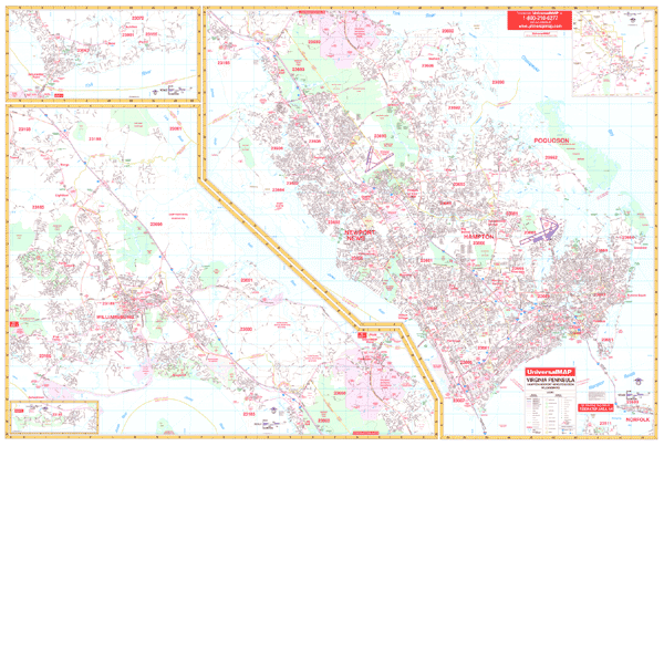
VIRGINIA PENINSULA WALL MAP
2009 4th edition The Virginia Peninsula Wall Map by Universal Map offers complete street detail, up-to-date cartography, color, and lamination. Lamination allows the map to be marked on and wiped off easily. This wall map measures 77 W x 54 H. The map's area of coverage runs North to the James City County line; South to include the northern-most point of Norfolk (ties to Universal Map's Tidewater map); East to the Atlantic Ocean; and West to the James River. Insets provided with the map are to the Governor's Land at Two Rivers and Gloucester Point. The special features and data contained on this map are as follows: all streets, all highways, educational facilities, government buildings, shopping centers, hospitals, airports, recreational parks, post offices, golf and country clubs, points of interest, city limits and annexations, railroads, mileage circles, water features, cemeteries, fire and police stations, zip code and boundaries. In addition, for your convenience, the map is indexed in a separate book.
Framing rails are available on top and bottom for easy wall mounting. | |
 |
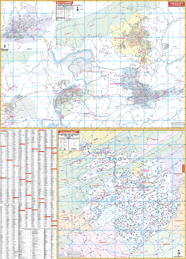
BLACKSBURG/CHRISTIANSBURG/ PULASKI WALL MAP
2002 1st edition The Blacksburg, VA Wall Map by Universal Map includes Christiansburg, Radford, and Pulaski with surrounding areas. This map measures 50 W x 72 H and provides up-to-date cartography in complete street detail with new streets and changes. This map is printed in color with a markable and washable laminated surface. The map's coverage is in two sections. Section I ranges North to Jefferson National Forest, Brush Mountain Estates; South to Interstate Highway 81; East to include city limit of Christiansburg; West to Dublin. There is an inset of the City of Pulaski. Section II offers the 4-county inset of
Montgomery, Floyd, Pulaski, and Giles. Other pinpoints feature government buildings, zip codes and boundaries, airports, golf courses and country clubs, railroads, city limits and annexations, post offices, shopping centers, cemeteries, educational facilities, fire and police stations, hospitals, recreational parks, water features, mileage circles, and points of interest, plus a complete index.
Framing rails are available on top and bottom for easy wall mounting. | |
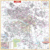 |
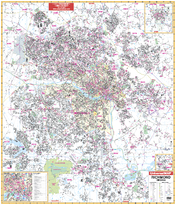
RICHMOND WALL MAP
2008 6th edition
Measuring 54 W x 64 H, the Richmond, VA Wall Map by Universal Map provides
compete street detail and up-to-date cartography. Coverage: North to the
Hanover/Henrico Co. line including Hanover Co. Municipal Airport: South to
include Walthall Mill at Exit 58 of the Richmond-Petersburg Turnpike; East to
include the I-295 Loop out to the interchange of I-295 and I-64; West SR 288;
Protected by a markable laminate surface. Framing rails are available on top and
bottom for easy wall mounting. | |
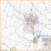 |
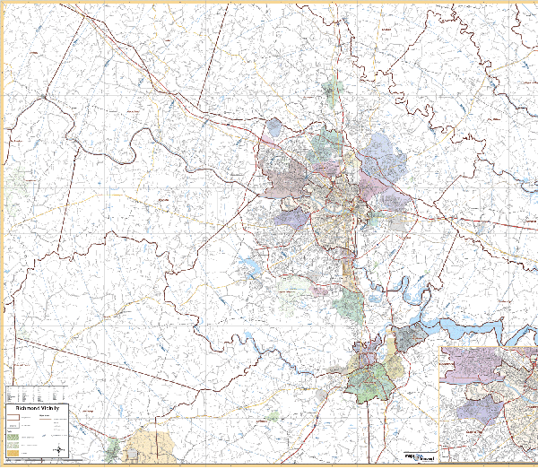
RICHMOND/VICINITY VIRGINIA WALL MAP
2007 3rd edition The Richmond, VA Vicinity Wall Map by Universal Map provides coverage for an approximate 35 mile radius from Richmond. Measures 61” x 48” with colorful, up-to-date cartography at a scale of 1” = 48”. Boundaries are as follows: North: 10 miles north of Ashland; South: 10 miles south of Petersburg, including portions of Fort Pickett; East: James City County line: West: to Columbia in Fluvanna County, Town of Amelia in Amelia County. Inset of Richmond. Protected by a heavy laminate surface.
Framing rails are available on top and bottom for easy wall mounting. Excellent source for routing or planning. | |
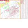 |
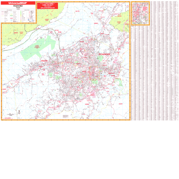
ROANOKE WALL MAP
2002 3rd edition Measuring 76 W x 54 H, the Roanoke and Salem, VA Wall Map by Universal Map contains up-to-date cartography and street level detail. This oversized reference is protected by a durable, laminated surface which is both markable and washable. Coverage ranges North to include Mt. Union in Botetourt County; South to the Franklin County line; East into Bedford County including the Blue Ridge Parkway; and West to Montgomery and Craig County lines including Berrybrook Dr. Also included is an inset map of Downtown Roanoke. Other data features government buildings, airports, golf courses and country clubs, railroads, longitude and latitude lines, zip codes and boundaries, shopping centers, recreational parks, mileage circles, cemeteries, educational facilities, hospitals, post offices, city limits and annexations, fire and police stations, section/township/range lines, longitude and latitude lines, and miscellaneous points of interest, plus a complete index.
Framing rails are available on top and bottom for easy wall mounting. | |
 |
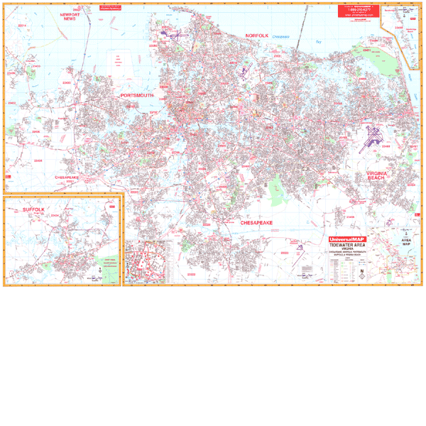
TIDEWATER WALL MAP 4TH EDITION
2009 6th edition The Tidewater Area, VA wall map by Universal Map provides up-to-date cartography plotted in complete street detail with new streets and changes. Printed in color and laminated making it both markable and washable. Coverage: North: to the Chesapeake Bay (ties to Universal Map of VA Peninsula); South: to include the communities of Fentress, Great Bridge, and US Naval Airfield (Fentress Sta.); East: to the Atlantic Ocean; West: to include all of the city of Suffolk. Streets are indexed in a separate book.
77" x 54" | |
|