|
Wall Maps
- State, County & Cities - Wyoming
GeoMart
is rapidly expanding its on-line selection of wall maps. If you
don't find what you are looking for here, please give us a call at
800-248-6277. One of our customer service representative will be
happy to assist you in finding the right map for you.
Most Maps Usually Ship within 48 hours.
Laminated maps with the option of hanging
rails usually ship in 5 days
 |
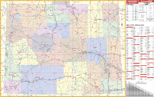
WYOMING WALL MAP
2006 2nd edition
The Wyoming Wall Map Universal Map measures 64” W x 43” H and has up-to-date
cartography at a scale of 1” = 7.2 miles. Features color-coded counties, mileage
chart between major cities. Details: state/federal/secondary highways,
cities/towns, major airports, major waterways, universities, military
installations, populations, state/national parks, points of interest. Printed in
color with a markable and washable laminated surface. Indexed on the face of the
map. Framing rails are available on top and bottom for easy wall mounting. | |
 |
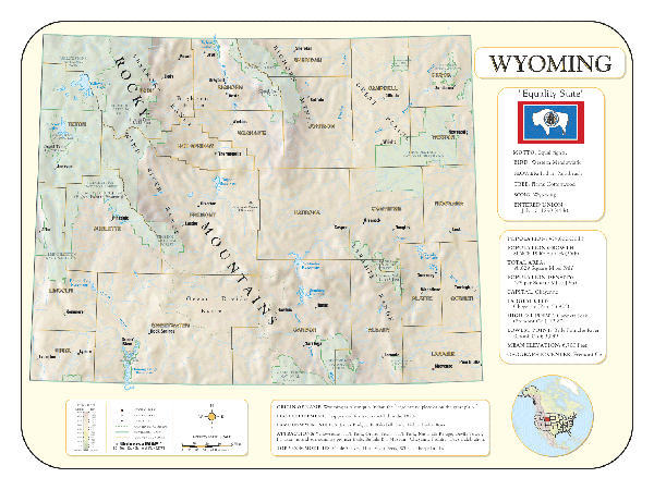
Raven Wyoming Map
This is the state where the Continental Divide and the Rocky
Mountains meet the Great Plains. Wyoming's beautiful rivers,
including the Yellowstone, Platte, Green, and Snake, contrast
with the rugged Rockies, especially the spectacular Big Horn
Mountains. Elevations are represented by color, and this, in
combination with our relief shading technique, gives the map a
3-dimensional look.
Raven Wyoming Map Dimensions: 43"
x 52" (approx.)
Raven Wyoming Map Scale: 1:500,000 or 1" equals about 8 miles. |
|
 |
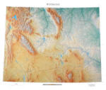
WYOMING SHADED RELIEF MAP
The Wyoming Shaded Relief Wall Map by Universal Map measures 48 W x 36 H and is a full-color, topographical wall map. Statistical information on this map includes historical, anecdotal, and geographical. There is also an elevation scale measured in meters and feet and a distance scale measured in miles and kilometers. Identifies county boundaries. Shows state flag. Lists state motto, bird, flower, and tree, plus total area, population and origin of name. Its heavy laminated surface can be used with waterbased pens. |
Click Price to Add to Cart | | Laminated |
$31.95 |
|
|