Featured Products

See some of our other fine products

Click on image for more information

Search our Site

Build you own USGS topographic map

The Perfect Gift


Gift Certificates


Tell a friend

about GeoMart:

Acceptance Mark

Pre-Approved Purchase Orders

GeoMart

516 Villanova Court

Ft Collins, CO 80525

800-248-6277

800-321-6277 Fax

Nautical Charts Books and Publications


Maptech Chartkits: Nautical Charts in Book format

Order Maptech ChartKits and Accessories


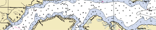
Used by generations of boaters, Maptech ChartKits are full-color reproductions of U.S. government and private charts spiral bound into popular cruising regions. The convenient-sized books are large enough to allow for manual plotting, yet small enough to sit on your nav-station or lap.


Order Maptech Embassy Guides

Embassy Guides are the perfect navigation companion when you're planning your trip and underway. They're filled with detailed with navigation advice and are an enjoyable read. Maptech offers 7 guides covering from Maine to Florida and the Bahamas.


Cover of Coast Pliot 2

View or order Coast Pilots

The United States Coast Pilot consists of a series of nautical books that cover a variety of information important to navigators of coastal and intracoastal waters and the Great Lakes.


Light List

The USCG Light List is published in seven volumes and contains lights and other aids to navigation used for general navigation that are maintained by or under the authority of the U.S. Coast Guard and located in the waters surrounding the United States and its Territories. Each volume corresponds to a different regional area and contains more complete information on each aid to navigation than can be conveniently shown on charts.


Photo of Eldridge Tide and Pilot book


Add this to your cart! 

$11.95 

2008 134th Edition


Eldridge Tide & Pilot Book

The chances are that if your great-grandparents went boating somewhere on the Atlantic coast, a copy of the ELDRIDGE TIDE AND PILOT BOOK was on board. Since 1875, when George W. Eldridge published the first edition, ELDRIDGE has been the most relied-upon source for helpful information about tides and currents, and a whole lot more.

In the new edition, you'll find the latest tide and current tables for the Atlantic coast, pages on GPS navigation, radiotelephone use, lights and fog signals, courses and distances, safety and weather for the mariner. Printed every year, ELDRIDGE appears in November in many marine stores and bookshops.

Not only is it loaded with valuable information, it's the least expensive guide of its kind available. That's why it's been a bestseller since 1875.

Be coastwise, and make your ancestors proud at the same time.


NOAA Chart No 1 Cover - Nautical Chart Symbols, Abbreviations and Terms

View or order Chart No 1

Chart No. 1 Nautical Chart Symbols, Abbreviations and Terms is a reference publication depicting basic chart elements and explains nautical chart symbols and abbreviations associated with National Ocean Service and Defense Mapping Agency charts. It is a valuable aid for new chart users and a useful tool for all mariners.


Atlantic and Gulf Coast Catalog Cover

View or order a NOAA index

Do you need an index?  You can download one here or order a paper index to be delivered to you.


Nautical Chart Section

Dates of Latest Editions

Make sure you have the latest NOAA chart for your boating needs.